By Sean Quinn and MJ Johnson
Back-to-back Taylor Swift concerts at Lumen Field, Seattle Mariners vs. Toronto Blue Jays, Bite of Seattle and the Capitol Hill Block Party plus closures on the I-5 Ship Canal Bridge, SR 520, and SR 18 - all in the same weekend. The question for us is how do we help the public comprehend the volume of people moving through Washington state, and get where they need to or want to go? Enter, Paint Maps.
For a little less than a decade now, a summer tradition has both entertained and informed our social media followers to plan ahead and know before they go. These artistic masterpieces, affectionately known as our Paint Maps, are made by our Communications team to prepare travelers for most busy summer weekends. We’ve been asked what goes into makes these and why do we do them?
It’s a simple recipe really: A Google map base layer, some detailed but straight-to-the-point text boxes, and of course, the doodles. The not-so-perfectly drawn, but good enough combination. All to reach as wide an audience as possible to keep folks aware of what’s happening each busy summer weekend. But a lot of behind-the-scenes work goes into getting them from the planning stage to the eyes of tens of thousands. While it’s still winter, why not start thinking of warm sunshine while we take a deep dive into the creation of our weekly summer Paint Maps!
History
 |
| A collage of many Paints Maps that we’ve put out on social media the last eight years (2016-2023) |
Simply doing a text post for every project with some basic pictures can get stale. During the summers from 2014 to 2016 we would occasionally go live on Facebook, showing the various big impact events and construction/maintenance coming across the entire state using a handy-dandy whiteboard with illustrations drawn with expo pens. We also started adding some silly drawings to the mix. It got folks’ attention, and ultimately that’s a major goal. A more informed traveling public is a better traveling public.
 |
A WSDOT communicator using a white board and drawings on a hand drawn Washington state map to show impactful events and construction taking place during
a busy summer weekend back in 2015 |
Back in June of 2016, ahead of a jam-packed summer weekend (Pride weekend, Sounders and Mariners games, a car show, etc.) we wanted to come up with a new and creative way to get our message across, and one of our communicators did a quick doodle in Snipping Tool. All it took was a map and some pretty colors, and voila.
 |
A screenshot from the first ever WSDOT Paint Map, from the weekend of June 24-26, 2016. On the Paint Map, events include Hoopfest, a busy I-90 weekend, Mariners and Sounders games, Capitol Hill Pride, and a car show
in Greenwood, Seattle |
You never know how some of these outside-the-box ideas will go over, but to our delight the picture got a lot of admiration on the platform formerly known as Twitter (now X). While the map wasn’t exactly a masterpiece, comments at the time called it a “beautiful piece of art.” No sense in re-inventing the wheel, we made it a weekly thing every summer weekend for the next seven years. Typically, that means once a week every Thursday/Friday from Memorial Day through Labor Day weekends (with a few exceptions here and there). Why summer? That’s when the busiest weekends are for construction, maintenance, and special events!
The process – Data collecting
What is the process of making the Paint Maps? First comes getting the information, go straight to the source.
First things first, a group of about 50 of our statewide communicators meet at the beginning of each week to discuss work crews have planned for the week and the weekend ahead, along with any noteworthy major events taking place. Throughout the week, as work plans change and weather forecasts come in, we keep each other updated.
 |
| An example of an email sent from the writer of the Paint Maps to our Communications team, noting the events and construction we have Labor Day Weekend, 2023 |
Whether it’s through a virtual meeting, phone call or email, all of this information makes its way to two communicators: the designers of the Paint Maps. Yep, it’s a two-person crew that turns a whole lot of text into digital artwork (oh, and before you ask – they do lots of other work too, not just the Paint Maps).
Trust the process – Creative writing
One communicator takes all the information and filters it into a hefty bullet point list with: What the work is/name of the event, where it’s taking place and the timeframe. Some weekends, the list is as small as 6-8 items, others it’s more than 16 and requires some adapting like removing some of the less-impactful ones or making two Paint Maps for one weekend. In most cases, it’s not that we forgot about a particular event, it’s that we just can’t fit EVERYTHING on the map.
Once the team filters the list of items down to a manageable load, typically 15 or less, the writer finalizes their work in the text blurbs that later go on the map. The blurbs are written in the same style: Name of the event/what’s closing, location of the event/work, and the start time (event) or duration of work (construction/maintenance). The written blurbs are then sent to the artist.
Trust the process – The doodling
Now for the magic, the doodles. The artist takes the information and chooses drawings that are appropriate for the work being done. If there’s a festival or concert, a logo or portrait of the musician/event may work. If it’s construction on a bridge, maybe a drawing of a bridge, maintenance vehicle, or traffic cone. The possibilities are endless.
Now, it’s time to reveal the sources behind the magic. Although Microsoft Paint served us well for many years, we switched over to using Canva in 2022. This speeds up the process and allows for more detail in the drawings such as Taylor Swift, Beyonce, and even Seattle Kraken mascot, Buoy.
Okay, what’s next?
Next comes the actual artwork. Here’s how it works:
Step One: The first step is to go to Google Maps and take a snapshot of the state that includes where all the work and events are happening. Then we add the WSDOT logo at the bottom right, weekend dates at the top right, and identify which direction is north (we love geography).
Step two: Next is adding in all those written blurbs to the areas where the work or event is happening.
Step three: Then we add all the transparent circles and arrows that point to where the work/events are taking place.
Step four: Now that the basics are done, we get to the fun part, the doodles.
You may be asking, with all that detail, are you really free handing everything? The simple answer is no. Not everything is free-handed, but a majority are! The traffic cones, bridges, cranes, maintenance vehicles and so on are generally all drawn by hand. It’s the more detailed drawings where we get a little help. For those, the communicator uses tracing methods for more inspiration and guidance.
Once the doodles are completed, they’re placed onto the map next to the blurbs. A lot of moving around of blurbs and doodles is done to make sure the map is clean and readable. Sometimes if there’s not enough room, we may have to cut an event or two and do more re-arranging until it all looks pretty.
The final product – The post
Once the Paint Map is finished our team posts them on our social media channels including X (formerly Twitter), Facebook, Instagram, Threads and Reddit. And sometimes, even TikTok if we’re feeling cheeky! Then it’s rinse and repeat the same formula every week until the summer ends.
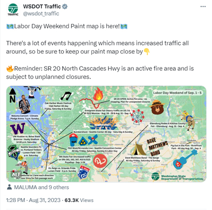 |
A tweet from the WSDOT Traffic X/Twitter account with the Labor Day 2023 Paint Map attached. The tweet says the Labor Day paint map is here, and there’s a lot of events happening which means increased traffic all around so good to keep the Paint Map close by. It also says that at the time of the tweet, SR 20 North Cascades Highway was an active fire area and was subject
to unplanned closures. |
The future
As the popular expression goes, “If it ain’t broke, don’t fix it.” As long as the public continues to (for the most part) like them, and they’re getting the vital traffic information they need, we’ll keep doing them! As for the future, the looks of the Paint Map may change here and there, but the formula will remain the same. Whatever it takes to get the word out about our busy summer, we’re doing it. The Paint Maps are not meant to be perfect creations, but useful infotainment. We’ll keep painting pretty little trees and traffic cones, as long as the public continues to appreciate them!
Paint maps from years past
 |
| The Paint Map from the weekend of Sept. 15-18 2017 |
 |
| The now-infamous Taylor Swift-themed Paint Maps from the weekend of July 21-24, 2023 |
Want to browse a selection of our favorite Paint Maps from years past? Check out our Flickr album of them here: https://www.flickr.com/photos/wsdot/albums/72177720315315201


