Thursday, July 27, 2023

Roundabouts are coming to I-405 in Totem Lake – everything you need to know

UPDATE: 2:07 p.m. Tuesday, Aug. 29

Northeast 132nd Street is scheduled to reopen from its two-week closure on Monday, Sept. 4. Once the street is reopened, there will be a temporary configuration of single-lane roundabouts at each previously signalized intersection. Construction will still be ongoing and the final configuration of multilane roundabouts will be complete this winter. Expect delays and plan extra travel time in the area while construction continues into its final stage. We appreciate your patience.


By Victoria Miller

It’s been a busy summer of construction and while the traffic congestion from construction has been difficult, the good news is that we are making progress on our projects.

In Kirkland, the I-405/NE 132nd St Interchange Project has made significant progress and is scheduled to be open to traffic by the end of this year. As you may know, the project builds a half-diamond interchange with a new northbound on-ramp to Interstate 405 and a new southbound off-ramp from the highway. As part of the project design, the intersections of the new ramps will include roundabouts.

While we have seen roundabouts implemented into several construction projects across the state in the past, this will be the first set of roundabouts in an I-405 interchange as well as the first set of roundabouts in Kirkland.

How do you drive a roundabout?

Roundabouts are designed to make intersections safer and more efficient for drivers, pedestrians, and cyclists. There are two basic types of roundabouts: single-lane and multi-lane. The roundabouts being built for the I-405/NE 132nd St Interchange Project will be multi-lane roundabouts.

There are a few key things to remember about driving through roundabouts:

  • Be aware of pedestrians as you enter and exit the roundabout
  • Yield to drivers already in the roundabout (on the circulating roadway)
  • Stay in your lane; do not change lanes
  • Do not stop in the roundabout
  • Avoid driving next to oversize vehicles

In a multi-lane roundabout, you will see two signs as you approach the intersection: the same yellow "roundabout ahead" sign and speed signs used for single-lane roundabouts, and a black and white "lane choice" sign. This second sign is to help you choose the appropriate lane for the direction you want to exit the roundabout.

You choose your lane in a multi-lane roundabout the same way you would in a traditional multi-lane intersection. Generally, to go straight or turn right, you would use the right lane. To go straight or turn left, you would use the left lane. Usually, you can also make a U-turn from the left lane as well.

The graphics below show which turns can be made from each lane at the future Northeast 132nd Street roundabouts. Arrows in yellow show movements that can be made from the left lane, and arrows in orange show movements that can be made from the right lane.

Rendering of the future roundabout to the west of I-405 intersecting with the future southbound I-405 off-ramp. This graphic shows travelers coming from the west driving eastbound on Northeast 132nd Street. Kingsgate Park and Ride is in the bottom left corner of the rendering.
Rendering of the future roundabout to the east of I-405 intersecting with the future Northeast 132nd Street on-ramp to northbound I-405. This graphic shows travelers coming from the east driving westbound on Northeast 132nd Street.

After selecting the appropriate lane, yield for pedestrians in the crosswalk as you approach the roundabout. Before entering the roundabout, look to your left and yield to drivers already in the roundabout. It is important to remember that in a multi-lane roundabout, entering traffic must yield to both lanes of the circulating road. If there is no traffic in the roundabout, you may enter without yielding.

When there is a gap in traffic, merge into the roundabout in the correct lane and proceed to your exit. Look for pedestrians and use your turn signal before exiting the roundabout.

Want to learn more? We also have a video available online about how to drive a roundabout .

You can also download our Rules of the Roundabout brochure in English and Spanish (PDF 379KB).

How do pedestrians and cyclists use roundabouts?

Modern roundabouts are designed to be safe for people walking or using mobility assistance devices. Vehicles are moving at a slower rate of speed in roundabouts - typically 15 to 20 miles per hour.

Crosswalks are set farther back from vehicle traffic, allowing more time for drivers to react to people crossing before merging into or exiting the roundabout. Triangular islands between lanes of vehicle traffic provide pedestrians moving through the roundabout a safe place to wait if they choose to cross only one direction of traffic at a time.

People using the crosswalk should look for approaching vehicle traffic, then move through the crosswalk to the triangular island. Before continuing, they should look for traffic entering or exiting the roundabout. When it is safe, they can continue through the crosswalk.

Bicyclists can choose to ride through the roundabout with traffic or walk their bicycles through the pedestrian crosswalks similar to a traditional intersection. Like people driving, bicyclists must obey the rules of the roundabout as they proceed through the intersection. Riders who choose to walk their bicycles may find that some roundabout designs have a ramp onto the sidewalk, making it easier for bicycles to transition from the roadway to the sidewalk.

Want to learn more? Watch a video about using a roundabout as a driver, pedestrian or bicyclist.

What to expect during roundabout construction

To build the roundabouts, there will be an approximately two-week-long closure of Northeast 132nd Street between 116th Way Northeast and Totem Lake Boulevard Northeast. The closure will begin as early as Friday, Aug. 18. There will be no vehicle access to this section of Northeast 132nd Street during the closure and a signed detour will be in place for travelers in the area.
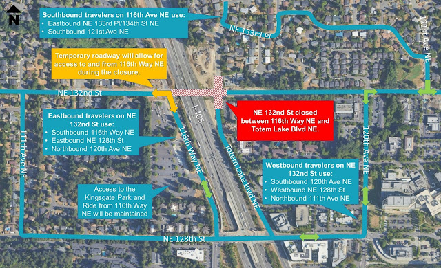
Detour map for the two-week-long closure of Northeast 132nd Street between 116th Way Northeast and Totem Lake Boulevard Northeast from Friday, Aug. 18 to Monday, Sept. 4.

Where can I learn more about the project’s construction?

To learn more about the project construction, how to use roundabouts, and additional details regarding detours, the project team is hosting an in-person project update meeting from 6-7:30 p.m. on Wednesday, Aug. 2 at the Kirkland Justice Center, located at 11750 NE 118th St in Kirkland.

If you are unable to attend the project update meeting, you can find more information on the project webpage . If you have additional questions, you can call our construction hotline at 425-224-2433 or email us at i405sr167program@wsdot.wa.gov.

To learn more about roundabouts in general, you can read about the safety performance benefits, traffic flow benefits, and operations on our roundabouts webpage.

Learning how to navigate new traffic configurations can be an adjustment, especially after having to navigate detours from construction. We want to make sure everyone is safely prepared for what’s to come to I-405 in the Totem Lake area. We’re almost there – hang tight and get ready!

Wednesday, July 26, 2023

Forks local has been picking up litter for 27 years with Adopt-A-Highway program and says he is just getting started

By Tina Werner

A lot can change in 27 years. Just ask 79-year-old Forks resident Paul Hampton.

In 1996, Ebay and Major League Soccer started. Movie crowds cheered Will Smith in Independence Day while everyone was doing the Macarena. The Sonics reached the NBA Finals, only to lose to Michael Jordan's Chicago Bulls. It was also when Paul decided to volunteer his time to pick up litter as part of the Adopt-A-Highway program in his community as part of the Forks Elks Lodge.

With the Adopt-A-Highway program celebrating its 33rd birthday this summer, we wanted to share the story of one of our long-standing volunteers – both to thank Paul for his service and to share a bit more about Adopt-A-Highway for others who may be interested in joining the ranks.

Paul moved to Washington from Florida in 1980 and began getting involved in his local Elks Lodge, attracted to the group’s vision for ongoing community service. He soon learned about our agency’s Adopt-A-Highway program and decided the Forks Elks Lodge needed to adopt a local stretch of highway in town to help keep their little corner of the Evergreen State clean and welcoming to visitors.

Forks Elk Lodge #2524 volunteers (left-to-right): Glen King, Paul Hampton, the late Gary Slyter and Bill Plumley stand by their highway sign a couple of years ago.

“It started as a group of people picking up trash along US 101 in town,” Paul said. “Then the local hospital thought it was a good idea to adopt a small stretch too.”

The community soon rallied around the idea of being part of something bigger and committed to routine litter cleanups. Before Paul knew it, people from all across the Olympic Peninsula saw the value in picking up litter.

“A group of women decided to participate in the Adopt-A-Highway program, so we had a friendly competition going with them too,” he said. Paul says the Forks community takes great pride in cleaning up litter to keep their community beautiful and he encourages others to consider serving – even those at his age.

Why do all this? Paul says his motto after being a retired Navy veteran and working for the Department of Natural Resources is to help people and make the world a better place.

Bags collected by the Department of Ecology Youth Corps program are picked up and disposed of by our crews.

Keeping Washington litter free

It takes a lot of work – and partnerships with local governments, businesses, law enforcement and fellow state agencies such as the departments of Ecology and Corrections – to clean litter from our roads, but the public also plays a crucial role.

We need the public to:

  • Properly cover and tie down all loads, on all trips
  • Keep trash and debris securely gathered in vehicles until you reach home, so it doesn’t fall out or fly out of vehicles
  • Properly dispose of all trash; do not dump it at rest areas, parking lots or other land
  • Share litter prevention messages with friends and family
  • If able, consider creating an Adopt-a-Highway group to join the valuable volunteers who help clear roadsides and other rights of way – like Paul!

Last year alone, our crews, partners and volunteers collected 1,402 tons of trash along state rights of way – roughly 152,500 bags of litter. This year as of July 20 we, along with agency partners and volunteers have collected 1,800 tons of trash and expect to surpass last year’s total.

Adopt-A-Highway volunteers pick up litter along SR 99 near Seattle. Most litter cleanup work happens between March and October depending on weather.

We oversee two different types of Adopt-A-Highway programs aimed at keeping the state’s roads clean and safe for residents and travelers.

  1. Volunteer groups
    • Groups agree to have their members clean up the "adopted" highway section four times each year and perform a valuable service to their communities.
    • We supply litter bags and safety materials/training and also collect full bags once a cleanup is complete.
    • Volunteer groups get their name on a roadside recognition sign within their adopted area, but no logo.
    • Details on how to get started as a volunteer group are available online.
  2. Contractors hired by sponsoring businesses/organizations
    • Businesses or organizations who choose to sponsor an adopted highway section agree to pay a private contractor to clean the area six times each year for a fee. (We approve all contractors and review contracts).
    • This can be the roadside, median or interchange (including some areas that volunteer groups aren’t assigned due to safety concerns).
    • Details on contractor sponsorships are available online.

A “family” of volunteers

What’s it like on a volunteer Adopt-A-Highway crew? Paul and his group of volunteers from the Forks Elks Lodge pick up trash like empty beverage containers, leftover fast-food bags and blown out tires from the shoulders of US 101. It’s not glamorous work, but the reward is knowing they’re making an important contribution to their town and their state.

In addition to the sense of service, Paul said he cherishes the relationships that have formed over the years through volunteering together along their adopted stretch of US 101. He describes his group as a family.

“People have started families, grown up together, had medical incidents or watched their children get married,” Paul said. “We always have people wanting to join our group and we welcome them.”

Litter cleanup is an ongoing effort and no matter how many volunteers we have picking up trash, it’s never gone completely. But Paul and his team give it their best effort – and he’s not slowing down anytime soon.

Paul and Elsie, his wife of 57 years, are living a wonderful life, he said.

“As long as I am still kicking, I plan to keep my own set of (litter) grabbers by my bedside,” he said.

Learn more about the Adopt-A-Highway program, including if an area near you is available for adoption online.

Monday, July 24, 2023

New day, new way in Seattle’s Montlake neighborhood

By Steve Peer

July 24 is a new day for the State Route 520 Montlake lid project as it ushered in a new way for people crossing a new highway lid via Seattle's Montlake Boulevard. Or, perhaps better put by Celine Dion, "A New Day Has Come."

For the past 10 days, crews closed Montlake Boulevard to work on realigning the street. We understand the stress and inconvenience road closures cause, but we have great news to share: Montlake Boulevard is finally getting its act together and straightening out!

This shows the three major changes that evolved after the recent 10-day Montlake Boulevard closure.

Three big changes to Montlake-area streets

The closure resulted in three big changes to the Montlake area. The first is a realignment of Montlake Boulevard that straightens the road for vehicles passing over SR 520. For the past two years this busy urban arterial, just south of the University of Washington, looped to the east so crews could extend the still-under-construction lid to the west.

During the 10-day closure, crews straightened the boulevard to a north-south alignment, making it easier for drivers to smoothly navigate the road. This change also marks an important transition in lid construction by opening room for landscaped greenspace on the future Montlake lid! Stay tuned for updates on the lid's construction and eventual planting of this new community gathering space.

This illustrates the finalized 3-acre Montlake Lid over SR 520 which is expected to open in early 2024.

With the 10-day closure behind us, the second change drivers will notice is a new westbound on-ramp to SR 520 from Montlake Boulevard. In the coming weeks, the new ramp will benefit pedestrians, as the new interchange features clearly defined sidewalk pathways.

There's a great deal more to look forward to for pedestrians and cyclists throughout the summer and fall as the final Montlake configuration creates new ways to navigate the area.

The third change – and the most exciting for those who regularly cross Lake Washington on eastbound SR 520 – is a new eastbound on-ramp from Montlake Boulevard. For the next few weeks, this on-ramp will carry vehicles to the SR 520 floating bridge via the new, 1.2-mile-long bridge we're building across Union Bay. Next month we'll open all three lanes of this new bridge to eastbound traffic. Later this summer, its twin Union Bay bridge to the north (presently carrying two lanes of SR 520 traffic in both directions) will revert to a three-lane, westbound-only bridge.

We thank the community for your patience and understanding during the boulevard's recent 10-day closure. We are pleased to bring this new day to SR 520 travelers and the Montlake neighborhood, but Montlake Project construction closures remain on the horizon until the project wraps up next year. Be prepared for detours and street or highway closures nearly every weekend during this busy summer construction season.

And, in case you haven’t had Celine’s lyrics stuck in your head (or haven't heard this fantastic song), here it is again for your listening pleasure.

US 101 to close north of Quilcene for 22 days

By Mark Krulish

Summertime is in full swing. You’re probably excited to hit the road for an adventure accompanied by the sun and clear blue skies.

There are plenty of great places to choose from, such as the Olympic Peninsula. You’ve probably already heard a lot about the work we’re doing there. We have a lot of fish barriers to replace, bridges to build and safety improvements to make. Most recently, we announced dates for a project near Sequim that will create long traffic backups for a week during the daytime.

One of the great scenic routes on the Olympic Peninsula is US 101 along the Hood Canal. And if you’re headed that way this summer, here’s your heads up – you’ll need to take a detour north of Quilcene in Jefferson County.

The project

We’re in the midst of a culvert replacement project at Leland Creek and two of its unnamed tributaries. At Leland Creek, just north of Lords Lake Loop Road in Jefferson County, we’re replacing a barrier to fish with a brand new bridge.

As you can see in the “before” photo below, the culvert here is inadequate for fish migration. The road here is currently under one-way alternating traffic controlled by a signal. It will remain that way until approximately Aug. 23.

The culvert at Leland Creek will be replaced with a larger structure to allow for better fish migration.

The project will also replace two more culverts underneath the highway north of the new bridge over Leland Creek. The culverts will be replaced with larger fish-passable structures that will allow for easier fish migration through the waterways that feed into Leland Creek.

US 101 Road closure

To replace the culverts, the highway will be closed around-the-clock to all traffic between Leland Cut Off Road and Lords Lake Loop Road from approximately 9 a.m. Monday, July 31 to approximately 7 p.m. Monday, Aug. 21. A detour around the closure will be on Center Road.

Travelers will see US 101 is closed, but open to local residents only. Please note this is done for the residents in the area. However, you won't be able to get through. Entire sections of the highway will be excavated. Follow the detour route and trust the signs. They're there for your safety.

To maintain that access for local residents within the closure, the culverts will be replaced one at a time. Work will begin July 31 and continue through Aug. 11 at the northern tributary crossing near Leland Cut-Off Road, which is approximately milepost 290.3. From Aug. 11 through Aug. 21, the culvert at the southern tributary will be replaced at approximately milepost 291.8.

In addition, State Route 104 will have a speed reduction from 60 mph to 35 mph between mileposts  4.08 and 4.62. A temporary traffic signal will be installed at the intersection of SR 104 and Center Road to control traffic.

Freight traffic will need to use this detour during the US 101 Leland Creek closure.

Weight restrictions

Near the southern end of the detour, traffic will have to drive over the Little Quilcene Bridge. That’s no problem for most regular vehicles, but the bridge does have weight restrictions for commercial and freight.

During the US 101 closure, larger vehicles will need to use a detour using SR 3 and SR 104.

Vehicles that do not meet these restrictions will have to take a different detour. Instead of using US 101 along the Hood Canal, you’ll have to take State Route 3 and SR 104 between Shelton and the Hood Canal Bridge to get around the closure.

Freeing the fish

If you’re a regular reader and traveler of our roads, you know we’ve ramped up our efforts in recent years to correct all of these barriers to fish under our state highways. This project replaces three culverts under US 101, which will open up the waterway and improve access to 14 miles of spawning habitat for Chinook, coho, steelhead and bull trout salmon.

These barriers hinder fish from moving upstream or downstream and returning to their spawning grounds. The culvert and pipes underneath our roads don’t work well for fish. Although water may flow through them, it may not be enough to allow fish to swim. Culverts may also have water that flows too fast or too slow. In some cases, the jump into the pipe or culvert may be too high. Fish migration is important to the environment and the Olympic Peninsula economy. We continue to monitor these restored fish passages long after construction is completed to ensure they are working as intended.

Friday, July 21, 2023

Final recommendations for improving SR 167

By Laurence Idos

After nearly two years of planning and collaboration with our partners and the community, we are ready to share final recommendations to improve travel along State Route 167.

But first – a recap! SR 167 connects Renton and Tacoma, one of the fastest growing areas in the Puget Sound region. As many of you are aware, the corridor has issues, including traffic back-ups, lack of transit infrastructure and service, and limited active transportation crossings.

In addition to technical analysis, we listened to feedback from community members and users over the past two years to inform our final recommendations. You may remember our online open houses, booths at fairs and festivals, and co-creation workshops. Some of that feedback included:

  • Importance of transit access and support for more frequent and longer transit service hours
  • Concern about increased traffic congestion on SR 167 and vehicle diversion to city streets; support for more managed capacity on SR 167
  • Importance of addressing bottlenecks; support for interchange improvements and auxiliary lanes at SR 18, SR 410/512, and SR 516
  • Support for low-income toll program to enhance equitable access to SR 167
  • Importance of filling gaps in regional trail network and providing more ways for people to reach their destination
A map of the SR 167 study area

Recommendations

The SR 167 Master Plan final recommendations offer sustainable transportation solutions to address the diverse needs of the community. By addressing the limitations of the current transportation system, we aim to reduce barriers and create a more inclusive and seamless experience for everyone. The recommendations include:

  • Adding a lane in each direction to create a dual express toll lane system
  • Improving nine interchanges
  • Increasing transit service and routes
  • Improving access to transit stations
A look at the results of the SR 167 study. This can also be found on the project website linked above.

What’s next?

The next step is to obtain funding to develop a SR 167 Implementation Plan. The SR 167 Implementation Plan will continue coordination with partner agencies and corridor stakeholders, including equity representation, to develop a prioritized phasing and funding strategy. To deliver the critical mobility improvements for SR 167 communities, $2.5 million in legislative funding is needed for the SR 167 Implementation Plan. Once funding is secured, the I-405/SR 167 Corridor Program will oversee the SR 167 Implementation Plan and work to implement the recommendations. Ongoing collaboration with you and our local jurisdiction and equity partners will be important to fully realize this plan.

Thursday, July 20, 2023

Fixing fish barriers on US 12 and SR 8 means temporary traffic changes and hopefully happy orcas

By Angela Cochran

We love orcas. Who doesn’t? But lately we have heard the orcas may not love us so much. While the so-called “orca uprising” is mostly happening in European waters, we do have a lot of orcas in the Pacific. We also have a lot of fish habitat improvement projects on the Olympic Peninsula this summer. Coincidence? Not really. While the goal isn’t so much to prevent the orcas’ supposed revenge, these projects will increase the number of fish (a.k.a. orca food) in the ocean. Without their natural food source, it’s clear who the orcas will turn to when they are hungry. …see why these projects are so important?

OK, that last part may not be true, but they are important.

One of these projects in Grays Harbor County will have five work zones for about two years on US 12 and State Route 8 between Montesano and east of McCleary. We are removing barriers to fish at three locations under US 12 and two locations under SR 8. Outdated culverts under the two highways make it difficult for fish to reach habitat. This in turn impedes their migration and prevents successful spawning. The culverts we are fixing under US 12 carry water to Wenzel Slough, Vance Creek and Camp Creek. Two culverts under SR 8 convey water to Wildcat Creek and Mox Chehalis Creek.

Crews will set up three work zones on US 12 and two work zones on SR 8
that will be in place through late 2025.

Reduced lanes and speed limits

If you have traveled US 12 or SR 8 recently, you may have seen some daytime lane and shoulder closures. Our contractor started working to set up the work zones on June 12. They have been doing survey work and installing temporary lighting. As each work zone is set up with the temporary lighting and barriers, the speed limit will be reduced from 60 mph to 50 mph around it.

Crews installing the temporary lighting at the Wenzel Slough work zone

Once the work zones are set up, crews will start building crossover lanes as a way to keep people moving through each work zone. Crossover lanes create a route for traffic through the median. People then travel on the other side with one lane in each direction. Building the crossover lanes will take about a month at each location. We started work at Wenzel Slough near Elma this month.

Shifting lanes ahead

We expect to shift traffic onto the crossover lane at Wenzel Slough by the end of September. Then crews will move to the next location at Vance Creek also near Elma, then Camp Creek near Montesano. After completing the crossover lanes on US 12, crews will move to SR 8 and build the crossover lane for the Wildcat Creek work zone, then finally Mox Chehalis Creek. Travelers will see the temporary changes until the end of the project in late 2025. We’ll keep people moving through the new work zone by reconfiguring the highway to accommodate both directions of traffic on one side. You might remember we took the same approach on SR 8 in the McCleary area several years ago.

The crossover lane will look similar to the one pictured here from a past project near
the middle fork of Wildcat Creek in McCleary.

Once traffic is shifted, crews will work on the eastbound side of the highway first at four of the work zone locations. This means that eastbound traffic will be shifted to the westbound side of the road. The other location, Camp Creek near Montesano, will have traffic shifted to the eastbound side of the highway while crews work on the westbound side first. This traffic pattern will remain in place for up to a year. Next summer, traffic will shift onto the opposite sides of the highways at each location.

Both directions of traffic will travel on the same side of the road around the work zone.
Traffic divider sticks will separate the lanes.

We’re gonna need a bigger culvert … and four bridges

We will replace four culverts with new bridges. The new bridges for the Wenzel Slough and Vance Creek worksites may not look like a bridge while driving over them. The contractor will build full-span bridges at the Camp Creek and Wildcat Creek locations. Crews will bring in a pre-cast box culvert for the stream that flows to Mox Chehalis Creek. Box culverts are larger than the culverts of the past. They allow a more natural stream flow, and fish can easily swim through them.

Each location will also feature a lot of work to improve and restore each creek. During construction, crews will rebuild each streambed by using a mix of gravel, varying-sized rocks and logs. This will support fish as they move through each lifecycle.

Why all this fish barrier removal work?

While not exactly an effort to prevent orca attacks on boats – or us – the work is related to our commitment to help salmon recovery and comply with state laws. We created the Fish Passage Barrier Removal Program in 1991. The program fixes barriers that restrict or block fish access under state highways. To date, we have corrected hundreds of barriers that have restored access to over 1,000 miles of fish habitat.

In 2013, the U.S. District Court issued a decision requiring Washington state to move more quickly to correct fish passage barriers. These creeks are among many fish barrier removal projects included in the federal ruling.

Improving access in these creeks means young fish will grow enough to make it to the ocean, and spawning salmon will have a place to return and lay eggs for the next generation. This is good news for everyone (especially us and the orcas).

Let’s work together to keep everyone safe

Reduced speed limits, roadway signs and installation of extra lighting around the work zones help keep our workers and all roadway users safe. We also need your help. Plan ahead by using our app and real-time map and allow extra travel time. Whenever approaching work zones please remember to:

  • Slow down – drive the posted speeds, they are there for your safety.
  • Be kind – our workers are out there helping to keep you safe and improve the roadways.
  • Pay attention – both to workers directing you and surrounding traffic; put your phone down when behind the wheel.
  • Stay calm– expect delays, leave early or take an alternate route if possible; no meeting or appointment is worth risking someone’s life.

Wednesday, July 19, 2023

It’s the Final Countdown: Alaskan Way Viaduct Program will wrap up its final project this summer!

By Leiona Islam

Bring out the confetti! The South Access: Surface Street Connections project, the final state-led project of the Alaskan Way Program, will be completed this summer!

What will I see when it's done?

The project has been doing road work in Seattle near the south end of the State Route 99 Tunnel, finishing work that couldn't be done while the Alaskan Way Viaduct was still standing. A signature piece of this project is a new pedestrian corridor on Railroad Way South, connecting the new Alaskan Way to Seattle's sports stadiums.

Demolition of the viaduct ramps on Railroad Way South in 2019 and the same location, four years later – the new pedestrian corridor on Railroad Way South!

The project is also building a new section of bike/pedestrian trail and a new equipment garage for the SR 99 Tunnel's South Operations Building that will hold equipment used to maintain and clean the tunnel.

Completing this project is a win for providing more multimodal options near Seattle's stadiums and represents a final step in the area's transformation after the demolition of the old Alaskan Way Viaduct.

Cool video! Now what's next?

Viaduct demolition in 2019 opened up space for a reimagined central Seattle waterfront. The South Access: Surface Streets Connection project is just a small part of that larger reimagining, which is being led by the City of Seattle's Office of the Waterfront and Civic Projects.

The new pedestrian corridor on Railroad Way South was actually designed as part of the Waterfront Seattle improvements. We are thankful to the Waterfront Seattle team for their continued partnership while we constructed their vision for this area. The new pedestrian plazas will tie beautifully into the pedestrian, bicycle and transit improvements being built along the waterfront just to the north by the City of Seattle, connecting more neighborhoods to a new world class Waterfront Park. Check out what Waterfront Seattle is building here! And if you have questions, you can reach us at viaduct@wsdot.wa.gov.

Tuesday, July 18, 2023

Taking advantage of SR 18 maintenance closure July 21-23

Last westbound I-90 lane reduction set for July 24-27

By Tom Pearce

Lane reductions and closures will return to State Route 18 and Interstate 90 starting this weekend, with a maintenance closure of SR 18 between I-90 and Issaquah-Hobart Road. This section of SR 18 will close starting at 9 p.m. Friday, July 21, and continue through noon Sunday, July 23.

The work on I-90, which starts Monday night, July 24, will be the last of the multi-day lane reductions on the westbound interstate.

SR 18 weekend closure

Between I-90 and Issaquah-Hobart Road, our maintenance crews will do preservation work along SR 18, including drain-cleaning, clearing line-of-sight for travelers, repairing guardrail and temporarily patching potholes.

While SR 18 is closed between I-90 and Issaquah-Hobart Road for maintenance this weekend, the contractor on our I-90/SR 18 interchange project will take advantage of the closure to complete some work for their project, avoiding a separate closure later.

When possible, we try to combine work to lessen disruptions for people traveling. In this case, we have a couple of projects working to widen SR 18 that will take advantage of the maintenance closure. Our I-90/SR 18 Interchange Improvements project will do drainage work and complete bridge inspection along a two-mile section of SR 18 south of I-90. Drilling and surveying crews working on the SR 18 Widening project will collect data between Tiger Mountain and Issaquah-Hobart Road. This project is still in design and will begin construction when the first project is complete in 2025.

I-90 lane reductions

We’ve occasionally been reducing lanes on sections of westbound I-90 between Preston and Issaquah for about a year now, but this should be the last multi-day reduction. We need three days to replace a section of a bridge where the deck meets the road.

Earlier this year we replaced a bridge approach on westbound I-90 west of Preston. When we did that work we determined a portion of the bridge deck needs to be replaced. It will take three days for that work, starting Monday night, July 24.

The work will reduce westbound I-90 to one lane for 72 hours straight, leaving one left lane open from 9 p.m. Monday, July 24, to 9 a.m. Wednesday July 26. When that is finished, our contractor crews will flip traffic over to the right lane so they can repair the left side of the freeway. That will take until 9 p.m. Thursday, July 27.

While some overnight work remains, this project will finish later this summer.

Preserving our highways

These projects are examples of the work we need to do to keep our state’s highway system in good shape. When these highways were built, they carried far fewer cars and trucks. As use increased, so has wear and tear as well as demand.

The work on SR 18, along with a project to build a new I-90/SR 18 interchange, will help keep people and commerce moving. On I-90, this section is more than 40 years old and needs rehabilitation. We know it’s inconvenient when we have to do this work, but in the end, people will have a better transportation system. Thanks for your patience!

Monday, July 17, 2023

Prepare for slowdowns on US 101 between Sequim and Gardiner

By Cara Mitchell

If you’re traveling on US 101 between Gardiner and Sequim in mid-August, we need your help.

From 7 p.m. Sunday, Aug. 13 through the evening of Friday, Aug. 18, we are reducing US 101 to a single lane near the Clallam and Jefferson County line in Gardiner. For five days, traffic on US 101 will alternate at Eagle Creek while crews open the road to remove a culvert and replace it with a large box culvert that is fish friendly.

The culvert at Eagle Creek will be removed and replaced with a large box culvert
that will be easier for fish to pass through.

You might think that closing one lane isn’t a big deal, right? Think again. Historically, every time our crews close a lane of US 101 for ongoing maintenance or emergency repairs, the traffic backups are very long. We know this, as do residents and businesses. Please help us spread the word about this upcoming lane closure and proactively prepare for delays by planning.

What to expect

Based on traffic volumes, our traffic engineers expect congestion to start building after 9 a.m. each day on US 101 between Chicken Coop/Diamond Point Road and Guiles/Knapp Road. This is where the work zone is located. Backups approaching the work zone will continue late into each evening.

Some of the heaviest congestion is expected from 5:30 p.m. to 6:30 p.m. each day

  • Monday, Aug. 14
    - 7-mile back up approaching the work zone – 1-hour 15-minute delay
  • Tuesday, Aug. 15
    - 3-mile backup approaching the work zone – Up to 50-minute delay
  • Wednesday, Aug. 16
    - 6-mile backup approaching the work zone – 50-minute delay
  • Thursday, Aug. 17
    - 6-mile backup approaching the work zone – 1-hour 15-minute delay
  • Friday, Aug. 18
    - 8-mile backup approaching the work zone – More than 1-hour 45-minute delay

We need help from travelers

The projected backups will happen if people don’t change their plans. Drivers can help improve travel times by:

  • Running errands early in the morning or late in the evening
  • Give yourself plenty of extra time to reach your destination if you can’t delay travel.
  • Consolidating travel, or carpool
  • Working from home or remote office locations if possible
  • Carrying extra food and water as an added precaution for emergencies or unexpected stops
  • Staying calm. Delays are frustrating, but no meeting or event is worth risking injury or death.
  • Have a full tank of gas

We don’t have another state highway that can easily detour traffic around the work zone. For this reason, we can’t close US 101 completely during this work. Instead, there will be one lane open. A traffic signal will move traffic through the work zone – please treat it as you would any signal, for everyone’s safely.

If a third-party app is telling you there’s a back route around the work zone, we ask that you consider not taking it. The communities on the Olympic Peninsula need their local county roads available for emergency response. We will have signs up reminding drivers that local roads are for local access only.

Olympic Discovery Trail

The nearby Olympic Discovery Trail and the Jefferson Transit bus stop at Diamond Point Road will remain open throughout construction. From Aug. 13 to Aug. 18, pedestrians and bicyclists may experience heavy congestion on the trail, including people accessing the trail via the Diamond Point Road parking lot. During this time, bicyclists and pedestrians will detour around the work zone on the Olympic Discovery Trail. The map below shows the bicycle detour and the nearby work zone on US 101.

We have many tools to help you stay informed both before you go and while traveling:

Why do this work in August?

There’s truly no good time for major roadwork on state highways. People rely on the highway for everything from moving freight to getting to their doctors’ appointments. We're mindful of the inconveniences.

We’re restricted to a short time when we can do this type of work. These kinds of projects have what we call “in-water work windows,” which is the time of year that we’re allowed to do this type of work due to environmental considerations. This window is usually in July or August.

To minimize disruption, we’re using the ‘get in, get out’ approach. Crews will work around-the-clock to get the work done as quickly as possible. This approach consolidates the work into shorter periods of time rather than months of construction.

During this time, we’re digging up the entire highway. We’ll remove the existing culvert and replace it with a new structure that will carry Eagle Creek under US 101. We then will rebuild the highway. Until that’s finished, we’ll keep travelers moving on a temporary one-lane bypass around the work zone.

Could this work get delayed?

Yes, it could get rescheduled because of weather. It could also get delayed due to unforeseen product availability or staffing issues. We’re working with the contractor to try to avoid these issues as best we can.

If the schedule changes, we will share the latest information once it becomes available via our project web page.

Crews preparing for correcting the Eagle Creek culvert located under US 101

For the fish and us

This project will remove barriers to fish passage by replacing culverts under US 101. A fish passage barrier is anything that hinders fish from moving upstream or downstream. Culverts, large pipes under roads, allow water to flow but may not allow fish to swim through. Culverts may block fish because the water flow is too swift, too shallow, or has a waterfall into or out of the culvert.

Correcting these barriers is an important part of the state’s efforts to restore salmon runs, ultimately benefiting the Olympic Peninsula’s landscape and economy.

Will more work zones see traffic backups like this?

Six culverts will be replaced under US 101 as part of this project. This is the only location, however, that requires days of one-way alternating traffic. The remainder will include crews building two-lane temporary bypass roads around each work zone. Each culvert location has unique characteristics that help determine the type of work zone needed to correct the fish barrier. We work with our contractors to keep traffic moving at each location.

Safety first

Please watch your speed in work zones. Travelers will begin seeing work crews near Eagle Creek starting the week of July 17 as they begin site preparations for replacing the culvert. The regulatory speed limit will be reduced from 55 mph to 25 mph in the work zone from Aug. 13-18. Traffic fines are double in work zones. Always give construction crews the room they need to get this work done. Keeping your eyes on the road and slowing down helps keep you, our crews and other drivers safe. Delays are frustrating, but we are encouraging people to stay calm. No meeting or event is worth risking injury or death. We need travelers help keeping everyone safe on our highways.

Thursday, July 13, 2023

No “ex-Seuss” for most ferry trips during Lewis and Clark Bridge closure

By Kelly Hanahan

Starting Sunday, July 16, the Lewis and Clark Bridge (also known as the Rainier Bridge) on State Route 433 in Longview will fully close for up to eight days of construction. During the closure, people driving will detour to either US 101 or Interstate 5. This is a LONG detour! So be extra prepared or consider postponing your trips if you can.

The Wahkiakum County Ferry carries people and vehicles between Cathlamet and Westport, Oregon. It will run twice an hour around the clock while the bridge is closed — but please know that it should only be used for urgent trips, because its priority will be emergency response and those with medical needs.

“But why can't you just borrow a bigger ferry from all of those Seattle people?!” That's one of the most often asked questions, and we get it! We wish we had more ferries, too. Unfortunately, there aren't any extra ferries available to be used in this location, so we're sticking with the small but mighty, “Oscar B” to get us through!

While the Wahkiakum County Ferry will be running 24/7 during the Lewis and Clark Bridge closure, it's very limited capacity means heavy priority will be given to emergency responders and those with significant medical needs and appointments.

So, what does this mean for the average person who wants to drive their car onto the ferry? We want to be really honest; it may very well be stressful and frustrating! Here's why. …

The ferry will have a priority lane managed by law enforcement and contractors only to be used by:

  • Ambulances and first-responder vehicles on return trips from the hospital in Longview
  • Healthcare workers and first responders commuting to work (who will show their badge!)
  • People going to dialysis, chemotherapy or similar crucial but non-emergency medical appointments (pack your appointment documentation, like an email or text, if possible)

These will likely fill a lot of the ferry's 23-car capacity, so everyone else should expect to wait in long lines for hours.

As a public service to help head off frustration, we pulled together a few examples of when you should not plan to take the ferry during the bridge closure:

You should not board to coif your hair.
Nor plan a trip to groom your mare.
The same to reupholster a chair.

Don't trek to recycle aluminum
On the small but mighty Wahkiakum.

Postpone your trip to fly a kite.
Hold off on LED patio lights.

Please understand the time's not right
To harvest clams or gather berries
If your route requires the Wahkiakum Ferry.

We hope that helps make the distinction clear. Keep in mind that if you're walking or biking you will be able to cross the bridge during most of the full closure. For all of those access details, check out our project website.

Wednesday, July 12, 2023

Deep breath everyone … we’re heading into monster roadway closures in Seattle

By Steve Peer

Travelers will encounter what we’re calling “monster” roadway closures on and around State Route 520 in Seattle starting Friday night, July 14. Early warning: It’s not going to be pretty. In a nutshell, we’re closing parts of the SR 520 bridge across Lake Washington for two weekends in a row (July 14-17 and 21-24). Moreover, we’re closing Montlake Boulevard, one of Seattle’s busiest streets, during that entire 10-day stretch.

What? Why?

We’re aiming to complete the SR 520 Montlake Project early next year. This is a major phase of SR 520’s ongoing reconstruction between Interstate 5 in Seattle and I-405 on the east side of Lake Washington. The Montlake Project’s final stages, unavoidably, require several significant closures.

We know these closures are tough. The good news is drivers will see significant progress at the end of this “monster closure.” We’ll straighten Montlake Boulevard into its final north-south alignment. We’ll also open two new SR 520 on-ramps from Montlake: one westbound and one eastbound. The eastbound on-ramp will link to a new, three-lane eastbound bridge between Montlake and the SR 520 floating bridge. (We like to call the new eastbound span the world’s longest on-ramp to the world’s longest floating bridge.)  

Even more exciting is that drivers will see a new, landscaped lid over SR 520 by early 2024.  Here’s a visualization of the lid upon its completion and you can see a larger version of it on our website (PDF 476KB).

More about the ‘monster’ closures

The upcoming closure details are a bit wonky. There are several moving parts so please bear with us:

I-90 closure adds a wrinkle

This one is important! Crews will close eastbound I-90 from 11:59 p.m. Friday, July 14 to 7 a.m. Saturday, July 15 for testing fire suppression systems in the tunnels. We’ll keep eastbound SR 520 open during that I-90 closure - though please note that there is a toll to use that SR 520 bridge. After I-90 reopens, SR 520 will fully close across the lake for the rest of the weekend. We will close SR 520 again the following weekend from 11 p.m. Friday, July 21 until 5 a.m. Monday, July 24.   

Why do this when there are Mariners and Sounders games this weekend? We have a TON of work to get done this summer, as this blog explains, and there are essentially no weekends where there are no big events, as this blog highlights.

Montlake Blvd will close for 10+ days

During the SR 520 closure, we’ll also shut down Montlake Boulevard for 10 days, around-the- clock, starting at 10 p.m. Friday, July 14. That’s a big deal for drivers headed north/south to or through Seattle’s Montlake neighborhood. Right now, Montlake Boulevard has an awkward curve. That curve was necessary to keep travelers moving while crews build the new lid. After the monster closure ends Monday, July 24, Montlake Boulevard will shift to its new, permanent home, making for a smoother north-south drive through an improved highway interchange.

Bikes and Pedestrians

Good news: If you’re riding, walking, running or rolling though this closure, we’ve got you covered! The 520 Trail across the lake will stay open and we’ll even direct you north and south along Montlake Boulevard.

Give me the details

To get the most up-to-date information on this or other planned travel restrictions, visit and bookmark the SR 520 Construction Corner map.

Monday, July 10, 2023

I spy. … orange on I-5!

By Kris Olsen

If you’ve driven on Interstate 5 in the Fife area in the past month you probably noticed that a portion of it has a new look. It’s gone orange!

In early June, we painted half of the traditional white lane lines with orange between Porter Way and Wapato Way in Fife for the SR 167 Completion Project. This is the first time in the state we’ve used bright orange contrast lane striping in a work zone. This pilot project will gather information to help us and the Federal Highway Administration determine whether orange lane striping is an effective tool that can be used by highway departments across the nation to improve safety for drivers and workers in construction zones.

Orange striping was put in on I-5 in Fife about a month ago as part of a pilot project to see if it improves safety near work zones.

Any results yet?

Within days of the orange striping on the roadway, we started getting the question, “Do you have any results yet?” The short answer is no. The longer answer is that we’ll gather data and information through the end of the summer. Then, it’s going to take some time to process it and draw conclusions. We anticipate the results will be turned in to the FHWA in early 2024. Anecdotally on social media, we’ve heard some people say it’s definitely helped bring more attention to the work zone, and others say people are still going too fast through there.

Your opinion counts in the pilot project

If you’ve gone through the area recently, we’d love to know what you think of the orange striping. Take our orange striping survey anytime through July 30 to share your opinion. The survey asks questions such as the time of day you went through the area, whether you thought the orange striping increased your awareness of the work zone, if it was easy to see the lanes (especially in the dark or rain). There are also demographic questions (totally optional) that help us understand our audience better and if we need to increase efforts to reach different people who live, work and drive through the area. Other statistical data we’re collecting for the FHWA includes vehicle speeds, collisions, work zone intrusions and lane changes. All the information gathered in our survey will be included in the study results sent to the FHWA. We collected similar information before the orange striping so we can compare before and after results.

Why we’re trying orange striping

The safety of road crews and people traveling on our highways is always our top priority – every day. That’s why we use concrete barriers, bright orange barrels, illuminated arrow boards, and construction signs and reflective safety clothing. In areas with long-term lane shifts, such as I-5 in Fife where we’ve shifted lanes to the right while we build new bridges, faint “ghost” stripes from old lane lines are often still visible and can confuse drivers. The orange striping allows us to observe whether contrast striping enhances driver awareness of the work zone. We want to know if it:

  • Improves drivers’ ability to maintain lanes.
  • Improves compliance with posted work zone speed limits.
  • Increases driver awareness of work zones.
  • Reduces work zone collisions and intrusions.
We will share results we get from this pilot project with the Federal Highway Administration as they studied new tools to improve work zone safety.

“Work zone collisions don’t just affect construction crews,” SR 167 Completion Project Engineer Tom Slimak said. “Motorists and passengers account for 95% of the people hurt in work zone collisions. We want to make sure everyone gets home safely. Orange striping could be one more tool in our toolbox to make sure that happens.”

Last year, there were 1,192 work zone collisions across the state. Pierce County, where Fife is located, was the site of 22% of those crashes. That’s 274 collisions.

Doing our part to improve work zone safety

Four other states have also tested orange striping: California, Kentucky, Texas and Wisconsin. Each state applied the orange striping a little differently such as painting it next to the white lane lines or completely replacing them. Our application to the FHWA proposed using orange to replace half of the white lane stripes. Our information will be added to the data from other states to help the FHWA determine if orange lane striping can help increase work zone safety. If one of the variations works, it’s another safety method that will help workers and drivers.

But whether you’re driving through the orange-striped work zone in Fife, another work zone or no work zone at all we urge drivers to make good choices before and after getting behind the wheel: don’t drink/drug and drive, put away electronic devices, pay attention to the road, follow posted speed limits (especially in work zones). Driving safely is free! But a collision could cost everything for you or someone else.

Wednesday, July 5, 2023

Your guide to getting to, from and around the All-Star Week festivities

By Mike Allende

One of Major League Baseball’s biggest parties will be in Seattle when the All Star Game and its many events arrives at and around T-Mobile Park Friday, July 7 through Tuesday, July 11. Thousands and thousands of fans – many from out of town – will be arriving in the Puget Sound area to see some of baseball’s biggest stars.

While the majority of roadwork will be paused during the events, getting around is still going to be a challenge. Fortunately, there are A LOT of options. So whether you’re a T-Mobile Park regular or you’re wondering just how you’re going to navigate this major event, read on for a basic All Star Game Transportation 101.

So what’s happening?

Major League Baseball’s annual All Star Game – pitting the stars of the American and National leagues against each other – will be held in Seattle for just the third time (1979 and 2001 were the other two). But it’s not just the game, as there are many other events that are part of this.

  • Friday, July 7, T-Mobile Park: HBCU Swingman Classic, 7:30 p.m.
  • Saturday, July 8-Tuesday, July 11, Lumen Field/Lumen Field Event Center: Capital One Play Ball Park throughout the day.
  • Saturday, July 8, T-Mobile Park: Celebrity Softball Game and All-Star Futures Game, 4 p.m.
  • Sunday, July 9, Lumen Field: MLB Draft, 4 p.m.
  • Monday, July 10, T-Mobile Park: All Star Workout Day and Home Run Derby, 5 p.m.
  • Tuesday, July 11, T-Mobile Park: MLB All-Star Game, 5 p.m.
A look at the schedule of events for All-Star Week in and around T-Mobile Park in Seattle
(graphic courtesy Major League Baseball)

Driving to the stadiums

With so many people heading to T-Mobile Park and Lumen Field, driving will likely be extremely challenging and parking around the stadiums will be at a premium. That said, if you are planning to drive:

  • From the north, your primary options will be Interstate 5 or State Route 99. From I-5, exiting at 165A/James St. or 164/Dearborn St./4th Ave./Edgar Martinez Drive South/Airport Way South will put you near the stadiums. From SR 99 you would exit at the end of the tunnel, staying left to go to Royal Brougham Way, but note that the tunnel is tolled (more on that below).
  • From the south, the primary route would be I-5, exiting at Exit 163/West Seattle Freeway/Columbian Way, 164B/Edgar Martinez Drive South, or 164A/Dearborn St.
  • From the east, the primary route across Lake Washington would be I-90, exiting to 4th Avenue South or Edgar Martinez Drive South. SR 520 also goes across Lake Washington, exiting north of the stadiums so you’d get onto southbound I-5 from there, but note that the SR 520 bridge is tolled.
T-Mobile Park will be home to this year’s Major League Baseball All-Star Game and several other related events, bringing thousands and thousands of fans to Seattle.

Public transportation

There are a plethora of public transportation options to the stadiums, and they will no doubt be a very popular way for people to get to the events.

The primary carrier in the Seattle area is King County Metro Transit, which about two dozen different bus routes that stop near the ballpark. Sound Transit operates Link Light Rail from both the north and south, with the Stadium Station about a half-mile from the ballpark, and they are planning extra service. People can also exit at the International District or Pioneer Square stations. Sound Transit’s Sounder Train will also have special service to both the Home Run Derby on Monday, July 10 and All-Star Game on Tuesday, July 11 for fans traveling from the north and south, arriving/leaving from King Street Station which is about a half-mile from T-Mobile Park. King County Metro, Sound Transit and Kitsap Transit all will be fare-free on Monday and Tuesday to help get fans to and from the ballpark.

Another option is taking the Monorail, which runs between the Seattle Center (where the Space Needle is, for those not familiar) and Westlake Center in the middle of downtown Seattle – about 0.3 miles east of the Pike Place Market. From there people can take the bus or walk the 1.5 miles to the stadiums. The Seattle Department of Transportation also has a bicycle and scooter share program.

A ride-share lot also recently opened less than a half-mile from T-Mobile Park to make it easier for people to catch their rides.

With huge crowds and limited parking options, public transit like King County Metro buses is expected to be very busy for the All-Star Week events (photo courtesy Luke Distelhorst).

Taking to the water

The stadiums are near Puget Sound and plenty of fans will want to take a ferry either for fun or to reach the events. Our agency operates the largest ferry service in the country, and both the Seattle-to-Bremerton and Seattle-to-Bainbridge routes operate out of Seattle’s Colman Dock. There are no reservations taken for these routes. We welcome both passengers driving on as well as walk-on passengers and those riding their bicycles. (If traveling at peak times, walking on a ferry, if possible, is quicker than driving). More information about riding the ferry can be found on our website.

King County also operates the Water Taxi, with service from West Seattle and Vashon to Seattle’s Colman Dock. The Water Taxi is only available for pedestrians and bicycle riders, it can’t accommodate motor vehicles. Similarly, if you’re traveling from the west side of the Sound without a motor vehicle, Kitsap Transit offers Fest Ferry service between Colman Dock and Kingston, Bremerton and Southworth.

Riding the ferry is always a popular attraction, especially during the summer, and many fans will likely use the ferries to and from Colman Dock as part of their All-Star week experience.

Biking to the ballpark

Bicycling to the stadiums is a popular option. The city worked with Major League Baseball to denote “Green Path” for those biking and walking to the stadiums from downtown. Look for decals around First Avenue and Second Avenue. There are several areas for bicycle parking around T-Mobile Park, including inside the Mariners garage.

ORCA Card

The easiest way to use public transportation is using an ORCA Card. It’s the simplest way to pay your fare – you just load money onto the card and tap it at an ORCA reader. The card can be used on buses, ferries, monorail, water taxi, Link Light Rail and the Sounder train.

Tolls

There are a couple of toll roads people heading to the stadium may encounter. The SR 520 bridge across Lake Washington has a toll for those people going east/west, while the SR 99 tunnel also is tolled for those going to/from the stadium from the north. In both cases, we encourage people to set up a Good to Go account, which will allow drivers to save on the toll. Those who don’t have an account will receive a bill in the mail. There are temporary account options for visitors, but if you’re using a rental car be sure to check your rental agreement before you use a toll road as some rental companies charge additional fees for toll trips that we have no control over.

Safety

There are going to be A LOT of people going to the many events surrounding the All-Star Game. Public transit is going to be busy. Roads are going to be crowded. There is going to be a ton going on around the stadiums. Please be extra alert and patient, especially around T-Mobile Park and Lumen Field where there will be so many pedestrians out. Law enforcement will be out doing extensive traffic control – please follow their directions, don’t go around Road Closed signs and take it slow.

We will also have extra Incident Response Team workers out helping to clear incidents on highways. When you see flashing lights of emergency responders slow down and give them as much room as possible.

Sound Transit is adding additional service for its Link Light Rail trains heading to and from T-Mobile Park for Major League Baseball All-Star Week events (photo courtesy Luke Distelhorst

What my plan is

I’ve been a Mariners fan for 43 years, and I’m fortunate enough to be going to my first All-Star Game and events. As a (mostly) life-long resident of this area, I’m no stranger to T-Mobile Park but I know this is going to be special – and more challenging. I want NO part of the traffic or trying to park down by the stadiums so I’m going to give myself LOTS of extra time and take the Link Light Rail from Northgate Station to reach most of the events. I’m considering taking the Sounder train from Edmonds to the stadium on the actual All-Star Game day though I may stick to Link Light Rail.

However you plan to get around, please be safe, be patient, give yourself lots of extra time to get where you’re going, and have a fantastic time!