Thursday, June 20, 2024

Roadblocks and rockstars – ‘tis the season for summer construction on the way to your event

By Rachel Terlep

It's a tale as old as time. You grab your crop top or your cowboy hat, and you head to that concert you bought tickets for back in February. You roll down the windows, turn up the music and… construction. Great.

Don't take it personally. If you're heading to a big event this summer, you're almost certainly going to encounter road work along the way. In fact, it's impossible to find a summer weekend – or even a day – where there's not a concert, game, festival or event going on.

With 93 construction projects scheduled this summer – not counting day-to-day maintenance, emergencies and local city and county projects – there is a lot to get done in a short timeframe.
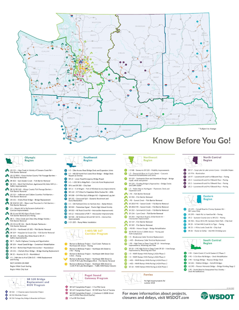
A map of the state of Washington that highlights 93 construction projects across the state. The greatest concentration of projects is in Puget Sound.
It's going to be a busy summer with 93 projects planned on and near state highways, not including other regular maintenance or emergency repairs. See a larger version of this image on Flickr.

That's just this year. Speaking of which, we have some good news and some not-so-great news.

The good news is once the work is done, our state will have safer and more accessible transportation systems and improved environmental habitats. The not-so-good-news, at least for the next few years, is that we'll have more summer construction projects than usual all over the state. And we do mean all, so your regular detours around major routes may have work as well.

Road workers and heavy machinery press asphalt near a new median barrier.
We'll be seeing a lot of construction projects this summer. This photo takes us down memory lane… to the summer of 2022, when we were putting the finishing touches on the I-5 Tacoma HOV program.

Why this time of year? Much of the work we do in the summer involves extensive work with concrete, and that means we need reliably dry weather for the concrete to fully cure. It also happens to coincide with a time when most of our professional sports teams are active, when we get a huge influx of concerts and when we have major events and festivals like Seafair, Watershed and Bumbershoot. That's not to mention the hundreds of smaller parades, community festivals and other events scattered throughout the season.

This is a calendar of major events happening in our state from June through September to give you an idea of why it's impossible to plan construction around those events. This calendar was created in early June, so other concerts and events may be announced as we move through summer.

A June calendar that encapsulates all major events happening in Washington. These events range from concerts, to festivals, to sporting events. Suffice it to say, there are a LOT of events captured here.
A July calendar that encapsulates all major events happening in Washington. These events range from concerts, to festivals, to sporting events. Suffice it to say, there are a LOT of events captured here.
An August calendar that encapsulates all major events happening in Washington. These events range from concerts, to festivals, to sporting events. Suffice it to say, there are a LOT of events captured here.
A September calendar that encapsulates all major events happening in Washington. These events range from concerts, to festivals, to sporting events. Suffice it to say, there are a LOT of events captured here.

How do you prepare for disruptions to your travel for the next several summers? Here's some advice from some of the musicians performing here this summer. Make sure this doesn't describe you: Salió de su casa con la mente encendida (In the words of Peso Pluma: “She left her house with her mind on fire.”)

YOU YOU YOU OUGHTA KNOW (Alanis Morissette)

Know what's happening, that is. We try to share information far and wide – from our social media accounts, to our website and app, to working with local media to get the word out. You can find our app and a list of our social media accounts at this website (scroll to the bottom to sign up for email/text alerts).

YOU SHOULD PROBABLY LEAVE (Chris Stapleton)

Early, if you can. Give yourself plenty of time to reach your destination.

G-O-O(d) T-O G-O (Chappell Roan… with a WSDOT twist)

You can take a Good to Go! It's handy if you'll use the SR 520 bridge or the SR 99 tunnel in Seattle, or I-405 to avoid heavy I-5 traffic, or possibly SR 167 to go to the Puyallup Fair or White River Amphitheater, or of course the Tacoma Narrows Bridge. Having a Good To Go! pass will also save you money and ensure you pay the lowest toll rate on all these roads. You can sign up or get more information on our website.

5 A.M. TURN THE RADIO UP (Pink)

And pay attention to road alerts. P re-program vehicle radios to 530 AM and 1610 AM for highway advisory radio alerts – and be alert for other stations listed on notice signs in some areas.

THERE GOES MY HERO / HE'S ORDINARY (Foo Fighters)

This is what we'll say about you if you consider alternative ways to get around – such as buses, bicycling, Link Light Rail, the Sounder Train, Amtrack Cascades or even organizing carpools. One great thing to keep in mind for people going to Climate Pledge Arena in Seattle: Every ticket to an event at the venue is also a transit pass.

I'M SO SICK OF SEVENTEEN…minute delays (Olivia Rodrigo…with a WSDOT twist)

There's not much you can do about that, but it's good to be in the right mindset before getting in the car. Accept that delays will happen. Try to stay calm. No concert or meeting or festival is worth risking injury or death.

IS IT WORTH IT? LET ME WORK IT (Missy Elliott)

We know added delays aren't fun, and we're working to minimize the effects where we can. We simply must make these repairs and improvements to our transportation system. Ultimately, some short-term pain will be worth the long-term gain.

The final stretch: Summer closures ahead, but finish line in sight for SR 520’s Montlake Project

By Nicole Phaysith and Steve Peer

An aerial view of a construction site with a bridge and a road under development, with a body of water shown under the bridge.
A west-facing look at Montlake Project progress in May 2024

Summer is almost here, and while we wish we were all sipping lemonade by the pool, major work is happening on the SR 520 Bridge Replacement and HOV Program's Montlake Project. We've encountered some delays along the way, and we're accelerating our pace to get back on track and complete the project by this fall.

Bottom line: We'll have two major closures each month for the next three months of the summer to minimize delays. The first major closure for June is already behind us! We're giving you an early heads-up on remaining closures so you can plan your summer adventures.

Remaining planned major closures*

  • June:
    • June 21-24: Montlake Boulevard, Lake Washington Boulevard and SR 520 associated ramps fully closed
  • July:
    • July 19-22: Montlake Boulevard fully closed
    • July 26-28: SR 520 fully closed
  • August:
    • Aug. 9-12: Montlake Boulevard fully closed
    • Aug. 16-19: SR 520 fully closed

During these closures, crews will wrap up a variety of major milestones for the project. This is including but not limited to work on utilities, paving, and landscaping on Montlake Boulevard, the Montlake lid, direct access ramp, bike and pedestrian bridge and more.

Closure caveats

  • *We want to emphasize that these closure dates are planned, and exact dates and details for closures will be confirmed as we approach each weekend.
  • Closure schedules are subject to change based on factors like weather conditions and existing summer events. As we all know, Seattle's summers are stunning and perfect for outdoor activities. The sunny weather also makes it an optimal time for construction. Closures – and the traffic disturbances they create in the summer – are unavoidable, unfortunately. That's why we want you to have as much advance notice to plan ahead.
  • These closures are not inclusive of all upcoming closures. There will still be local street closures and ongoing ramp closures. We encourage you to check our Construction Corner website for all the latest updates.

Stay in the loop

We're committed to keeping you in the know with all the latest updates. In addition to our Construction Corner website, be sure to follow us on social media and sign up for our newsletter to get the freshest construction news and closure notices.

Meme graphic of a video still image of two men inside a car with yellow text at the bottom reading, “Be a lot cooler if you check Construction Corner.”

Thanks for your patience

A huge thank you to all our Montlake and surrounding neighbors for your patience and understanding. We know it's a bumpy ride right now, but, we promise, smoother days lie close ahead. The line is in sight, and the improvements will be worth the wait.

Thursday, June 13, 2024

Galloping Gertie’s replacement is a Boomer, and it needs work

By Cara Mitchell

You’ve likely seen the memes about Boomers, Gen X, Millennials and Gen Z.

We have a new one for you, and it involves two bridges across the Tacoma Narrows:

Photo of Tacoma Narrows Bridge with Gen Z vs Boomer text overlay

Our 1950 westbound bridge, from Tacoma to Gig Harbor, is a Boomer.

The 2007 eastbound bridge, from Gig Harbor to Tacoma, is a Gen Z.

One is 74 years old while the other is still virtually a teenager.

In recent years, we’ve seen issues with our aging westbound bridge. The most recent episode was in mid-May when an expansion joint required us to reduce the bridge from four to two lanes for several days.

In late May, we discovered more issues on the same bridge involving a type of expansion joint called a finger joint. It is called this because it resembles a finger on a hand. These joints allow the bridge to expand and contract. The parts to fix it took a few weeks to be custom manufactured. You can’t order these parts off Amazon.

Photo of a cracked finger joint on the westbound Tacoma Narrows Bridge
Photo shows a cracked finger joint on the westbound Tacoma Narrows Bridge.
The finger joint will be repaired June 15-16, 2024.

The repairs this time mean the westbound SR 16 Tacoma Narrows Bridge will be reduced from four lanes to two from 4 a.m. Saturday, June 15, to 4 p.m. Sunday, June 16.

Image of Robert Downey Jr. as Tony Stark rolling his eyes
Real-time reaction from travelers reading that there’s more repairs on the way

Fortunately, this work could be scheduled over a weekend when there is less overall traffic. That won’t always be the case. Based on the age of the bridge, we know more emergency closures are in our future.

Years of underfunding both our highway Operations & Maintenance and Preservation programs have put our transportation system in jeopardy. Our highway maintenance crews provide short-term repairs like filling a pothole. Longer-term preservation work like roadway surfacing or bridge deck rehabilitation extends the life of our infrastructure. Both programs are needed to work in concert with one another. Unfortunately, given the number and age of our bridges, there is just not enough dedicated funding to keep them from developing age-related problems.

Tacoma Narrows Bridge crew members working under the bridge deck, fabricating forms
to pour new concrete during the emergency lane closures in May.

Lengthy repair list keeps growing

The westbound Tacoma Narrows bridge is one of the largest in our state bridge inventory. Given its age and how heavily it is traveled (45,000 vehicles each day, on average), it has a long list of repair needs including:

  • Replacement of expansion joints
  • Mechanical repairs of the elevators in the towers
  • Emergency electrical system supply upgrades
  • Rehabilitation of the superstructure damping mechanisms at the towers
  • Various structural repair needs throughout the bridge, such as tightening nuts, addressing rust and corrosion, replacing damaged rivets and bolts and replacing damaged structural members.
  • Fully removing and replacing the paint at the towers, trusses, cables and suspenders.

We have a preservation project designed to fix expansion joints on the westbound bridge that will extend the useful life of the bridge. The not-so-good news is that the project is delayed because we don’t have the funds to do the work. The earliest this project can now occur is 2026.

About those tolls

Before you type in all caps “whatabout those tolls,” a reminder that tolls don’t pay for maintenance on the westbound Tacoma Narrows Bridge. Tolling on the eastbound SR 16 Tacoma Narrows Bridge helps repay the costs to build the eastbound bridge, which opened in 2007. Tolls are only collected for trips headed to Tacoma, and toll rates are a fixed rate no matter when you travel. The Washington State Transportation Commission adopts state highway tolls.

Years of underfunding Operations & Maintenance and Preservation is catching up

Not having the funding we need means hard choices are made. Legally, we can’t overspend our budget. That means the agency must decide and prioritize which maintenance activities and preservation projects need to be delayed to stay within the budget we have. This is just like the tough choices people make with their personal budgets.

This is happening with the 1950 Tacoma Narrows Bridge and hundreds of other bridges and highways across the state. As of June 2023, 315 of our 3,384 bridges were 80 years old or older, accounting for 9.3% of all state-owned bridges. The number of WSDOT-owned bridges in poor condition increased 7% from 199 bridges in June 2022 to 213 in June 2023.

Washingtonians own a multimodal state transportation system that would cost nearly $200 billion to replace, but we’re not spending what we need to keep that system in good working order. This isn’t new information, and something our Secretary of Transportation and other agency executives have shared regularly with elected officials, local governments and other partners over the last eight years.

Both the Operations & Maintenance and Preservation programs aren’t about adding new things. Rather, they each play a role in taking care of what we already have.

For example, funding in the Operations & Maintenance program supports repairing potholes repairs, patching bridge deck patches and recent emergency closures on the westbound Tacoma Narrows Bridge. Planned preservation work, such as resurfacing a roadway or rehabilitating all the bridge joints in one project, are needed investments to keep the transportation system running smoothly.

Think of it like taking care of the roof on your house. Getting grime out the gutters and annual cleaning, that’s maintenance. Putting new shingles on, that’s preservation. You can clean a roof with old shingles and replace the shingle that is in bad shape. But, if you don’t put new shingles on your roof, eventually it will deteriorate over time and cost even more to fix down the road.

Maintenance crews holding things together

Photo of a Tacoma Narrows Bridge crew performing inspections high on the bridge
Tacoma Narrows Bridge crews perform inspections and
maintenance every week on both bridges

Our dedicated maintenance crew performs weekly detailed inspections and maintenance for both bridges. They identify, troubleshoot and address the many items needed to keep travelers moving. Their work is essential to the safe operations and extended service life of these bridges.

A separate team, our Bridge Preservation Office, also performs various engineering inspections (routine, in-depth, underwater, mechanical, electrical, structural) at set 1-year, 2-year, and 5-year intervals.

The point: we aren’t neglecting the bridge. It’s aging, and temporary fixes only go so far.  The team that cares for this bridge takes a lot of pride in their work. They strive to keep this span in the best condition they can. And it’s important to share this information so travelers understand what we are all facing.

More lane closures and extended drive times

There is never a good time to close lanes on the westbound bridge for emergency repairs. We know the weekday evening commute becomes brutal when this happens.

It wasn’t that long ago when there was only one bridge, and travelers had to plan an extra hour to cross the Tacoma Narrows during rush hour.

 So, why can’t we just move traffic to the other bridge during rush hour like Seattle’s Express Lanes?

While this seems straight forward, it isn’t as easy as it sounds.

Switching directions of travel across the State Route 16 Tacoma Narrows Bridge is possible. We designed it to work that way. But it works best for long term events. We did it in 2016 when the bridge decks were re-paved.

Putting this into place requires miles of traffic control barrels, reflective tape, cones and signs on both sides of the bridge. It requires reduced speeds in both directions and hours of set up. When you remove it, the entire process has to be repeated.  A switch like that when we’re closing lanes for emergency work would likely result in more backups – not less – for travelers.

Travel tips

When you hear another emergency repair is underway, have a plan in place. Alter flexible, non-essential trips. Telework if you can. Travel during non-peak commute hours if possible. Please know we’re doing the best we can in a tough situation and we appreciate your patience and any steps you can take to help lessen the congestion.

Real time travel information is available on the WSDOT app and the statewide travel map.

To take a deeper dive into our bridge performance measures, check out detailed bridge information found in our Gray Notebook.

Preserving our state highways, one chip seal at a time

By Brian Turner

Update: July 15, 2024

Work has started on SR 105, US 101 and SR 110. Drivers can see up to 15-minute delays through the work zones.


An image of Chip Seal, a seal wearing construction gear.  A quote below him says “Slow Down In Work Zones.”

At the Washington State Department of Transportation, we not only build roads – we maintain them. One of the methods we use is called chip seal. It doesn’t involve any swimming mammals, but it does help keep our highways smooth.

The chip seal projects apply a special protective surface to existing pavement. Basically, we lay down a sticky surface on the road and cover it with small chips of rock. The sticky surface and rocks get pushed into the road by traffic, creating a protective layer. It’s a cost-effective way to extend to life of a roadway.

This summer, our contractor will chip seal on six different sections of highway in Clallam, Grays Harbor, Jefferson and Pierce counties.

Grays Harbor County

  • US 101 – Grays Harbor Co Line to South of Lund Road - (6.5 miles)
  • US 101 – South of Lund Road to North of SR 107 (4 miles)
  • SR 105 – Whalebone Way to SW of Constantine Way (42.97 miles)

Jefferson County

  • US 101 – North of Big Quilcene River Bridge to North of Mt Walker Lookout Road (3 miles)

Clallam County

  • SR 110 – US 101 to Lapush Road and Mora Spur (10 miles)

Pierce County

  • SR 165 – South of Carbon River to South of 112th Street E (3.5 miles)

What to expect

Work is expected to start June 17. The projects will occur at various locations throughout the summer.

Crews will close lanes to perform the work. Typically, only one lane will be available for traffic to alternate in both directions. That means drivers will be taking turns traveling through the work zone, and traffic is guided by pilot cars or flaggers.

The speed limit will be reduced around the clock until a project is complete. The slower travel is not only safer for the people working on the road, but it also reduces the chance of damage to vehicles.

This work will cause travel delays. Travelers will want to plan for additional travel time and remember to bring along lots of extra patience.

Diving in deeper

A photo of the chip seal process being applied to a road.

Like a seal, we love diving deep and exploring. Join us as we explore more about how the chip seal process works:

  • Clean Up: First, the road surface gets a cleaning to remove dirt and debris. Cracks might also be filled to create a smooth base.
  • Asphalt Shower: A thin layer of hot asphalt or an asphalt emulsion (mixed with water) is sprayed onto the road.
  • Rock Shower: While the asphalt is still hot, a layer of crushed rock (chips) is spread evenly on top. These chips are typically three-quarters inch or smaller.
  • Roll it in: Rubber-tired rollers press the chips into the asphalt, ensuring a good bond.
  • Loose Ends: The asphalt cures in a day or two. Then a sweeper removes any loose chips.

Why we chip seal

Chip seal isn't a magic solution for road repair, but it has several benefits:

  • Protects the pavement: It acts as a waterproof barrier, shielding the road base from water damage, which is a major cause of cracks and potholes.
  • Safety Benefits: The embedded chips create a textured surface, enhancing traction for vehicles, especially in wet weather. It also provides and anti-glare surface during wet weather.
  • Cost-Effective: Compared to a complete road repaving, chip seal is a much more affordable way to extend a road's lifespan by several years.

Not only does chip seal preserve road surfaces, it also improves traveler safety. The protective coat restores traction to prevent skidding, particularly on wet roads. It helps visibility by providing an anti-glare surface during wet weather.

We need your help keeping crews safe

First and most importantly, drive the posted speed limits and don’t drive distracted in work zones. The best thing you can do is slow down in work zones. That makes it less likely that your tires will kick up rocks. Most importantly, it helps keep the workers who are out fixing our roads safe.

Stay informed

To stay informed about chip seal work and all the other construction happening across the state this summer, download the WSDOT app to your smartphone. You can also check out where work zones are on our statewide travel map. Both have real-time travel info.

No matter where you come across our road work, the next time you see a chip-sealed road, know that it's not just a bumpy ride. It's a smart way to keep our roads safe and extend their service life.

This blog is Chip tested – seal approved.

Tuesday, June 11, 2024

Adventure awaits around the Olympic Peninsula even with road construction

By Doug Adamson

If nature is your happy place, you may be planning a road trip around the Olympic Peninsula this summer. Whether you are looking to camp, hike or simply relax on the beach, we have important information to help get you there.

We are in year two of a multi-year project that corrects culverts under state highways along the west side of the Olympic Peninsula. The culverts are barriers to fish. They are located under SR 109 and US 101 in Grays Harbor, Jefferson and Clallam counties. From Forks to Hoquiam or Ocean Shores to Pacific Beach, travelers will be navigating around numerous work zones this summer.

Heavy equipment excavates highway and removes culvert. Temporary bridge nearby keeps people moving through the work zone.
Lots of heavy lifting is needed to remove barriers to fish. Workers have dug up
the existing highway and demolished the old culvert.

Communities remain open, businesses accessible

Travelers will still reach their destinations and we will keep people moving during construction. Just plan a bit of extra time and know you'll be able to get where you're going.

There are typically two ways we keep people moving during fish passage projects. One is the “get in-get out” approach. This method involves closing a section of highway. We work with local partners to arrange the best detour route possible for each location. This approach can be more disruptive to travel in the short term, but it means we can get the work done faster.

Another approach is to build temporary lanes or roads within a work zone to move travelers around the closure area. With this approach, temporary signals also may be used to alternate travel lanes depending on traffic volumes. This usually means the work will take a little longer, but it keeps the road open so travelers can still use it the whole time.

Bottom line, you'll be able to get to your destination this summer, eat at your favorite restaurant, shop at your favorite store, hike your favorite trail or fly a kite at your favorite beach. We've worked with our contractors to reduce overall construction timelines and provide alternate routes or temporary lanes around work zones.

We also recognize the inconvenience road construction brings, especially during summer (more on that below in this blog). We've created an online open house for construction on the Olympic Peninsula to help you plan your trip. Real-time information is available on our travel center map and our app.

Here's an overview of upcoming detours and work zone set ups on SR 109 and US 101 for summer 2024:

Work on SR 109 – get in-get out approach

People who use SR 109 between Hoquiam, Ocean Shores and Pacific Beach will use detour routes while a total closure of the road is in place in 5 separate locations. A total closure will often shorten the overall construction timeline and help minimize the environmental footprint. That's why we're getting the word out about a series of total road closures on SR 109. The timing of each total closure will vary based on progress of work. More information is available on the project website.

Map of SR 109, US 101 US 12, SR 107, SR 8, SR 108 and US 12 in Grays Harbor, Mason, Pacific and Lewis County. Five orange dots show separate work zones on SR 109 between Hoquiam and Seabrook. North arrow points up.
Lots of work is planned in a short period of time on SR 109. Detours will keep
people moving around each road closure. 

Removing barriers to fish under state highways is far from easy. While the road is closed, crews dig up the highway at the culvert site to remove smaller sized culverts that block fish migration. Workers install a large concrete structure that allows fish to swim under the highway. Once crews install a new concrete culvert, workers repave and reopen the highway.

Temporary lanes and signals along US 101

We are using temporary lanes and traffic signals at six fish passage sites in Jefferson and Clallam counties. A new project on US 101 at the county line started in March. Work is also now underway at five additional sites. We are replacing outdated culverts under the highway between Ruby Beach and Lake Crescent. You'll also see a reduced speed limit of 25 mph at each work zone. It's important to slow down and pay attention in these areas to keep workers and all roadway users safe.

Map of US 101, SR 113, and SR 110 in Clallam and Jefferson Counties and Forks. North arrow points up. Map shows five locations labeled 1,2,3,27, and 28. 1 is located at Wisen Creek to Sol Duc River on US 101 at milepost 209.3. 2 is located on US 101 at Unnamed stream to Dowans Creek at milepost 182.2. 3 is located at unnamed stream to Downan Creek at milepost 181.2. 27 is located on US 101 at unnamed tributary to Branden Creek at milepost 169.4. 28 is located on US 101 at unnamed stream to Hoh River at milepost 171.29
Each work zone will have traffic signals that alternates travelers through a temporary detour road. 

Types of structures

Most of the sites along US 101 and SR 109 will have new concrete box culverts installed. Box culverts are pre-cast, meaning they are built at a separate location and brought in by trucks. In some cases, installing a box culvert can be done within several weeks during the time crews are allowed to work in the water.

At two of the locations, we are building full-span bridges. Bridges are built on-site and can take from several months to years to complete. This is why you will see work at the site east of Forks in summer 2025. The work zone south of Forks at the Jefferson-Clallam county line will remain in place through the end of 2026.

Existing culverts are pipes or tunnel-like structures that channel water under the roadway. These older culverts were designed before we fully understood the effects they would have on habitat. Over time, we have found that the culverts prevent fish movement. Now we are working to fix that by building larger culverts or bridge structures designed to meet the needs of fish. These structures are also resilient to future changes. We are restoring fish habitats and opening miles of waterways for fish to thrive, reproduce, and find food and shelter.

Images of the final product. Image on top shows new bridge built over creek. Image on the bottom is a concrete culvert that is much wider than original culvert.
Two final products after construction. One is a bridge that carries travelers
over the creek (top). The other is a large concrete box (bottom). 

How do we decide to use a detour or build a bypass lane

A number of factors are considered when deciding how to keep people moving around work zones using a closure with a detour or building temporary lanes. This includes:

  • The time-of-day crews are permitted to work is one. If they are limited to daytime work only, that means the project will take longer.
  • Lay of the land or topography. We look at whether there is room for temporary lanes.
  • Nearby infrastructure such as utilities.
  • traffic volumes
  • environmental factors such as endangered animals and plants.

At some of the sites, crews can only work during the day. This is due to an endangered bird, the marbled murrelet, nesting in nearby trees. Work hours are limited to two hours after sunrise and two hours before sunset.

In addition to guidelines related to endangered species, these projects are beneficial to other wildlife apart from fish. Replacing narrow culverts with more expansive bridge-like structures provides space for land animals to pass under the highway. We have seen these animals at some locations crossing under the new structures instead of in the roadway. Reducing conflicts with wild animals and vehicles is one way to help reduce collisions.

Why is the work happening during summer travel season

We can only work in the water when its least disruptive to aquatic life. This is often called a 'fish window' or 'in-water-work window.' This is why work is taking place during the busy summer travel season. We are also facing a deadline to get the work completed.

All 11 culvert locations are part of WSDOT's 2030 Fish Passage Delivery Plan to open 90 percent of habitat blocked by culverts beneath state highways. During summer 2023, we removed barriers to fish at six locations under US 101 between Hoquiam and Humptulips.

Each project also is part of WSDOT's ongoing effort to comply with a 2013 U.S. District Court injunction to correct barriers to salmon and steelhead in western Washington.

Our crews really appreciate your patience and kindness on the roads.

Whenever near work zones please:

  • Slow down – drive the posted speeds, they're there for your safety and the safety of our workers.
  • Be kind – our workers are out there helping to keep you safe and improve the roadways.
  • Pay attention – both to workers directing you and surrounding traffic.
  • Stay calm – leave early; no meeting or appointment is worth risking someone's life.

I-405/SR 167 Corridor celebrations highlight multimodal vision coming to life

Recently we celebrated not one but two milestones for the I-405/SR 167 Corridor Program. Monday, May 20 was an opportunity to mark the opening of one project and the start of another on the same day. These achievements provided an opportunity to celebrate the progress we are making toward a multimodal transportation corridor. By multimodal, we mean improvements that will help all users whether they take transit, bike, roll, walk or drive. These improvements:

  • address aging infrastructure
  • correct fish barriers by opening upstream fish habitat
  • connect communities, freight and Regional Growth Centers throughout the corridor

We have worked with our partners over the last 20 years to bring these improvements to life. Watch the video below to see how we marked these milestones with agency and elected officials, corridor partners, community members, contractors and the project teams.

What does this mean for you?

The opening of the new interchange in Kirkland means you can access I-405 and the Totem Lake area, a Regional Growth Center, more easily. The interchange has reduced pressure on nearby interchanges that were seeing increased traffic due to continued regional growth. Construction began in spring 2022 on the I-405/Northeast 132nd Street Interchange. These improvements are now open to traffic, including:

  • new on- and off-ramps to I-405 at Northeast 132nd Street.
  • two new roundabouts for better traffic flow.
  • enhancements for bicyclists and pedestrians.
  • improved drainage, water quality and fish barrier correction to open up over a half mile of new upstream fish habitat.
Roundabouts and on- and off-ramps at the new I-405/Northeast 132nd Street interchange.
Photo of new improvements at the I-405/Northeast 132nd Street interchange.

And as you can tell by our dual celebrations, we are not done yet. The I-405/Brickyard to SR 527 Improvement Project is just getting started. We recently shared a blog about the improvements which include key connections to Sound Transit's new bus rapid transit service. The groundbreaking ceremony signaled the start of heavy construction on this project which will continue through 2028.

Multimodal vision

The I-405/SR 167 Corridor Program is guided by the I-405 Master Plan and SR 167 Master Plan. These plans describe our comprehensive strategy to:

  • reduce traffic congestion
  • improve mobility and safety performance 
  • address aging and failing infrastructure, including seismic resiliency
  • accommodate planned regional growth
  • enhance quality of life for the environment and communities we serve in the 50+-mile corridor
  • correct fish barriers and create new habitat area
Working together with partner agencies, these plans will help us manage traffic demand through improvements that will help all users. Key parts of this plan include expanding the express toll lane (ETL) system to a dual ETL system and building the infrastructure to support bus rapid transit service. The program also improves community connections to the corridor for bicyclists and pedestrians. Working together, these improvements increase options for all users and provide a more reliable trip.

Monday, June 10, 2024

Going the extra mile: Incident Response Team members clear roads and help stranded drivers

By Mariah Johnson

In 2023, our Incident Response Team (IRT) drivers in the greater Seattle area responded to an incident once every 12 minutes. Nearly 31% of our Seattle-based IRT crew members have been hit while actively clearing another incident. There were eight IRT-involved collisions in 2023. Three of them occurred when our crews were on the shoulder. Moving over or slowing down is important for the safety of the IRT crews and also others using the highway. It's also the law.

Our IRT program was created in 1963. Since then, the goal has remained the same: help clear collisions, assist disabled vehicles and help remove large debris from our highways. Our IRT crews work diligently to keep traffic moving and keep people safe. They push or tow vehicles, provide a small amount of gas to disabled vehicles and even change tires. More commonly, IRT crew members help at collision sites on state highways. They play a vital role in keeping roads clear. Incident Response is instrumental to operating our transportation system efficiently. 

Over the years, the program has expanded and adapted. We now have more signboards, tow trucks and updated technology. These improvements allow IRT drivers to perform potentially dangerous tasks, such as towing, from the safety of their vehicles.

Meet IRT driver Matthew Matson

Matthew Matson has been an IRT driver for 17 years. Sometimes Matthew is on the shoulder helping someone change their tire. Other times his truck is in the center lane to protect a stalled vehicle with traffic passing at 60 mph or more on each side.

It's dangerous to be out of your vehicle to help change a tire on the side of the highway – you're in a vulnerable position where it is hard to keep an eye out for potential hazards. That's how Matthew got hit by someone going close to 60 mph on southbound Interstate 5 in Federal Way. Matthew was able to get back into his truck and close the door but couldn't buckle up in time. From the collision, he experienced a concussion, short-term memory loss, a bruised shoulder, and some difficulty balancing. It took going to occupational therapy for about two years for Matthew to feel like he made a full recovery.

IRT trucks with signboards mounted to them were first introduced in the greater Seattle area in 2018. After seeing an improvement in safety and driver response time, this became the new ideal standard vehicle. However, there is still a limited supply available. As vehicles need to be replaced, more trucks with new signboards will be brought in. Matthew says he sees a significant difference when he has a signboard mounted to his truck. Generally, he has more room to work because when people see the sign, they move over or slow down sooner. This is important for IRT drivers because as nice as it would be to have safer work zones with additional buffer space, sometimes that is not possible.

During the final three months of 2023, IRT responded to a total of 9,916 incidents statewide. On average it took 18 minutes to clear each incident. Matthew believes with more signboards attached to trucks, the safer their work zone is. More visuals and flashing lights give the public more time to slow down.

A picture showing the vehicles that the Incident Response Team crew will often use at collisions with variable message signs saying, "Slow down," and "It's the law."

Meet IRT driver Richard Somonski

Richard Somonski has been an IRT driver for 19 years. Throughout most of his career, he has reported out of the heart of Seattle.

Richard says that if IRT could have two trucks at every collision scene, they could block an extra lane and the scene could be safer for everyone. Unfortunately, sometimes there's just too many incidents to have that extra coverage.

Richard's favorite part of the job is being able to have a profound effect on those whose days are not going as planned. He says he always makes sure to educate drivers after helping them because it reduces the chance they will experience another flat tire, collision or empty gas tank. Another reason is because, even with all the sirens, flashing lights and cones, the message to “move over,” or “slow down,” still seems to get lost in translation. It is a combination of driver behavior, increased signage, ongoing driver education and robust outreach for work zone safety that helps keep the roads safer for everyone.

Richard wants the public to know that the IRT drivers all have families, and their goal is to get home safely, every day.

A picture showing IRT driver, Richard Somonski, changing a tire on the shoulder of northbound I-5 just north of Mercer Street in Seattle.

Trainings and procedures

When our IRT drivers are first arrive at a collision, they will take on emergency responder responsibilities, sometimes performing first aid. There is a lot more to being an IRT driver than helping clear a scene safely. Our drivers go through various trainings, such as first aid, Washington State Patrol driving classes, radio procedures and more. With a U.S. Army background, Richard was already used to having to do various trainings such as CPR and preparing for the unknown that comes with the job. He explained that some scenes can be a lot to take in. As an IRT driver, you are exposed to a lot – everything from conducting CPR to helping someone with a flat tire or trying to pull someone out of a vehicle. Sometimes they even assist emergency responders with a fatality.

We recognize that some incidents may be more impactful and memorable than others for our IRT crew members. We provide support for our team members who have experienced trauma on the job through programs such as the Employee Assistance Program or other Peer Support groups.

As of 2023, there are 86 IRT employees statewide and 69 dedicated IRT vehicles across the state. During the day, drivers are actively patrolling almost 3,400 miles of highway along major corridors such as Interstate 5.

Because of the increase in dangerous driving we're seeing on all roadways – including in work zones – we are working both in-house and with construction, union and legislative partners to improve safety in work zones for everyone. That includes new approaches in designing some of our work zones. We are also investigating new safety equipment. This could look like more full lane closures and more daytime work and delays in some cases.

When all is said and done, moving over or slowing down when you see crew members is important for the safety of everyone. We all have loved ones - moms, dads, children and significant others. So please, slow down or move over so we all can get home safely.

Thursday, June 6, 2024

21-day closure of SR 19 at SR 104 ahead during roundabout construction

By Mark Krulish

Roundabouts. They are a favorite topic to debate, around and around. What isn't up for debate is their safety benefits, which is why we are building them. Roundabouts have safer left hand turns and reduce the risk of t-bone and head-on collisions.

This spring, construction began a few miles from the Hood Canal Bridge to build two roundabouts on SR 104 – one at SR 19/Beaver Valley Road, and the other at Shine Road/Paradise Bay Road.

Crews began work in May at the SR 104 and SR 19/Beaver Valley Road location. At this location, we are building a three-legged roundabout. Since May 20, that intersection has had temporary turn restrictions. Only right turns have been allowed. Travelers looking to turn left at this intersection in either direction have been detouring to Center Road instead.

Beginning June 6, this detour will apply to all travelers who use SR 19/Beaver Valley Road from SR 104. Access to Beaver Valley Road from SR 104 will be closed around-the-clock for 21 days. Once the closure is complete, the SR 104/SR 19 intersection will return to only allowing right turns. That will remain until the roundabout is completed in late July.

Work at Paradise Bay Road/Shine Road begins in August

We'll begin building the roundabout on SR 104 at Shine Road/Paradise Bay Road later this summer. Right now, it's scheduled to begin in August. By that point, the SR 19 roundabout should be just about done. We also expect nearby construction on the Hood Canal Bridge to be finished by then. We will have short-term closures of access to Shine Road and Paradise Bay Road during this part of the project. Those closures will happen well after Labor Day. We'll announce the exact dates for those closures when we have them.

A design visual of a four-way roundabout on a state highway. The visual shows where two side streets connect to the roundabout. It is surrounded by trees and shows cars using the roundabout.

Why we build roundabouts

We know these roundabouts will make the road look and feel different. We decided to build roundabouts here because of the number of collisions and amount of traffic. We also have a budget and a roundabout was less expensive than an overpass. Our goal is to improve safety for everyone who uses the road. We also looked at the option of a signal at SR 104 and Paradise Bay/Shine Road, but the roundabout outperformed the signal, particularly during the peak commuting hours. The delay associated with a signal is about three times longer. Our modeling shows about 21 seconds of delay with a signal and only 7 seconds with the roundabout during peak hours.

A design visual of a roundabout in a rural area surrounded by trees and open space. The roundabout connects to three segments of road – one on the left, one on the right and one at the top.
A three-legged roundabout is currently under construction on State Route 104
at its intersection with SR 19

We've heard from the community that you are concerned about the need to slow down for roundabouts. There's a reason for that. The slower speed and the angle at which cars enter the roundabout helps reduce the severity of collisions. The slower speeds at the roundabouts make left turns at these two intersections safer and easier than they are now. However, roundabouts also allow traffic to flow freely. If there are no vehicles in the roundabout, you simply slow down and go through. At a signal, you might have to stop and wait even if there are no other cars around.

This video shows how the roundabout will work at Paradise Bay/Shine Road once construction is complete.

It's going to be a major change, but one we believe people visiting or living on the Olympic Peninsula will benefit from. We will keep you updated on progress of the project on the project website.