By Tina Werner
We can all agree that trash is unsightly and diminishes the natural beauty of our Evergreen State. Yet every day, anything from thousands of pieces of debris to mattresses or desks fly out of vehicles and end up along our highways. According to 2021 research commissioned by the Washington State Department of Ecology, 26% of litterers say they would be motivated to stop if “a friend, family member, or passenger asked me to refrain.” Who knew it was so easy?
So. …while we may not be your friend or family member, maybe you can pretend just this once: Please, please, please stop littering. Seriously. It’s illegal, it’s selfish and it’s gross.
We get asked about litter frequently – especially at this time of year. So we wanted to answer some of your most burning litter questions and share what you can do to help us in our efforts. (Hint: it involves not littering).
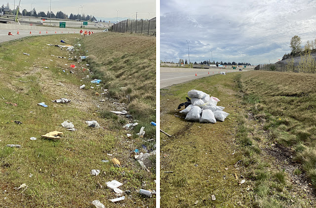
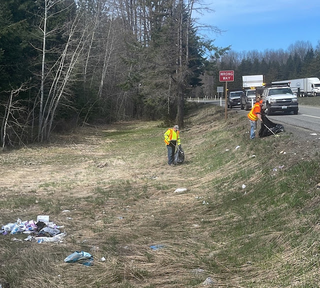 |
| Maintenance workers clean up litter along an eastbound I-90 ramp near Easton in late April |
But before we get to the questions, a quick look at where we’re at.
In 2022 our maintenance workers, crews from the Department of Ecology and the Department of Corrections and volunteers in the Adopt-a-Highway program collected more than 1,400 tons of trash – roughly the weight of six blue whales. We’ll keep working at it, but ultimately our workers can’t be everywhere picking up after people 24/7. We need the public’s help preventing litter from reaching the roads in the first place.
OK, on to the questions:
Q: I drive I-5 through (insert your city) five days a week and don’t see anything happening. Why are you never out there?
A: The most active litter cleanup work typically happens between March and November as cold, wet weather and less visibility makes it more unsafe in the winter. Once November hits our crews usually switch to winter-related maintenance work but now that spring is back, litter cleanup will become more active.
A typical litter cleanup job involves Ecology Youth Corps and adult crews bagging the litter and our crews collecting the bags and transporting them to landfills. In the first four months of 2023, crews have collected 1,648 tons (roughly 220,000 total bags) of trash. Our total for 2023 is only expected to increase as more litter pickup occurs across the state during warmer weather.
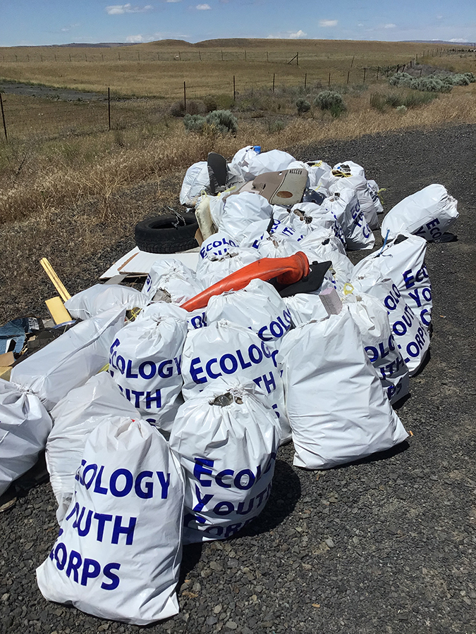
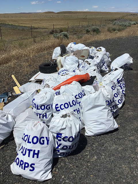 |
Department of Ecology Youth Corps collected a large amount of trash and other debris in eastern Washington this past summer and will be back
again this year across the state. |
You may be wondering why the spike in litter totals this year? For the early part of the year there has been an increase in cleaning at encampments, including some of the work in Governor Inslee’s and the state Legislature’s Right of Way Safety Initiative to offer housing to the people living in state rights of way and close encampments. At times a site can’t be cleared because housing hasn’t been identified but our crews can still clean up the area and/or do regular trash collections to help keep trash from accumulating or spreading. While the amount litter collected near encampments is significant, it’s also important to note that historically it’s not the major type of trash we clear from roadways. Once crews are out in full force this spring and summer we expect to see significant increases in the overall litter totals we also report from other items such as leftover lunches to larger items like mattresses and desks (which pose safety hazards as well as adding to roadside litter). Essentially basic, every-day litter.
The spring and summer litter crews include the Ecology Youth Corps crews, who work in July and August and are paid roles. Ecology’s adult crews work from March to November and are paid roles as well. More information about Ecology’s work crews are available by clicking this link.
Along with Ecology, we contract with the Department of Corrections to hire inmates who choose to participate in the program to gain professional work experience, earn some money and give back to their communities while being supervised. Our contracts prohibit participants with serious offenses or security risks.
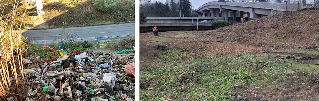
 |
| Here’s a look at the before and after of Department of Corrections work along I-5 near Tacoma. |
Q: Most of the trash has to be from encampments near the highway, right?
A: In 2022, approximately 466 tons of trash was collected near encampments statewide. In 2021, that number was 166 tons – almost three times less. People living homeless on state rights of way is a far-reaching issue that can’t be resolved by a transportation agency alone. When addressing litter associated with an encampment, we remove the debris and hazardous waste after an encampment site has been vacated – and must rely heavily on other state agencies, non-profits, local jurisdictional and behavioral health partners before a site can be cleaned. (As mentioned above, we may also do regular trash collections at some sites waiting for housing to be identified). The outreach and planning work to connect people with social and medical services and other options is key to closing encampments long term versus just having people disperse to another outdoor location.
 |
A look at litter under the SR 705 and I-5 interchange in Tacoma and after a contractor
cleaned the area in late January |
As far as addressing encampments, our maintenance crews and contractors work to clean them and we also work with neighboring jurisdictions to coordinate large-scale cleanups like in Tacoma and Seattle. For January through April of 2023, our maintenance crews and contractors reported they’ve cleaned up a combined total of 1,453 tons of trash from encampments across the state. Some of our crews utilize contractors for encampment cleanups while other crews do the work themselves to reduce costs. To date, contractors have collected and disposed of 176 tons of our overall 1,453 tons from encampments.
Q: You’re not doing enough when it comes to litter. Can’t you just allocate more money to your maintenance budgets to focus on litter cleanup?
A: Along with the Department of Ecology, we spend a combined $12 million on litter cleanup annually. Even with such a large expenditure, the litter problem is constant and increasing at rates greater than our crews, volunteers and partners can reasonably collect. The main need is to prevent litter on our roadways and rights of way in the first place, which is why we have supported Ecology’s latest litter prevention campaign, Keep Washington Litter Free. This campaign includes messages on our highway reader boards, a robust social media campaign and seasonal litter emphasis patrols by the Washington State Patrol.
 |
| Highway signs show a variety of anti-litter messages throughout the year. |
Highway maintenance work is prioritized and measured through a statewide accountability process based on funds allocated to us by the state Legislature and legal mandates we are obligated to meet for safety. In many cases we simply cannot defer critical maintenance work to focus only on litter – many of these other tasks are important for life/safety concerns. Roads must be cleared of ice and snow during the winter to keep people and goods moving. We also have thousands of miles of guardrail due for replacement and bridge decks that need repairs to extend their useful life. Our agency oversees approximately 18,700 lane miles, 3,300 state bridges and 120 miles of dedicated bike lanes across the state so there is a lot of work to do on a daily basis with limited funds.
Our roles in litter cleanup include:
- Responding and removing any trash in active traffic or posing an immediate safety risk
- Removing large items or debris (mattresses, couches) that potentially block traffic
- Removing roadkill
- Cleaning trash found near other roadside repair activities, as time allows
- Collecting and disposing of all bags of litter collected from roadsides by Adopt-a-Highway volunteers, Ecology Youth Corps crews and Department of Corrections crews
We work hard to balance the needs of our aging transportation system while also addressing litter as time and resources allow.
 |
| Maintenance crews pick up trash bags and debris along westbound SR 8 near McCleary |
Q: How did the COVID-19 pandemic affect litter pickup over the past few years?
A: Highway litter pickup was severely affected by the pandemic, including several litter cleanup programs put on hold due to safety and exposure concerns. That has led to an increase in highway litter. Due to COVID-19 safety restrictions, volunteer Adopt-a-Highway crews, the Department of Ecology Youth Corps and state and local departments of Corrections crews were not available for 2020 and parts of 2021 – meaning most of the “normal” highway litter cleanup did not take place or did so at reduced levels. Last year, due to the increase in trash after two years of a global pandemic, we increased our own litter duties statewide, while also focusing on graffiti removal, to help address the backlog.
Q: Why can’t you just fine people seen dumping furniture or trash bags along the highway?
A: The most important reason is we are not an enforcement agency and have no authority to issue citations. Enforcement on state highways is handled by the Washington State Patrol while local law enforcement handles other areas. Under state law, litter tickets and fines require the violation be witnessed by a sworn law officer. They cannot be issued based on reports given to or witnessed by our staff. Littering and illegal dumping are against the law in Washington. Fines range from $103 to $5,000. Many cities and counties have local ordinances that are stricter than the state law.
Q: There is a stretch of highway sponsored by a local business, and I don’t believe they are doing a good job at picking up the litter. How often do groups need to pick up trash to maintain good standing before possibly being removed?
A: There are two types of Adopt-a-Highway cleanup programs and they require a specific number of cleanings per year, rather than cleaning all litter as soon as it accumulates.
- Adopted areas: These are areas adopted by volunteer groups, which could be a group of business employees, a family, a club, etc. The group receives an acknowledgement sign for their efforts. Groups must clean their sites a minimum of four times a year.
If an adopted location has not been picked for more than six months, local agency coordinators will contact the group leader and request they act with urgency. If a group is unresponsive or not compliant with their agreement, they are notified that their agreement will be canceled, their recognition sign removed and their section of road made available to another group for adoption. This rarely happens; however, we have had to make the decision to revoke an adoption. Some of our groups have been participating in the program for decades and take great pride in their work as valuable volunteers to Washington state.
- Sponsored areas: For these sites a company partners with a state-approved contractor to clean a stretch of road – often areas where volunteers can’t operate due to safety concerns. The contract includes placing an acknowledgement sign recognizing the company’s efforts. The company’s name and logo – which must be reviewed by our agency -- also can only take up one-third of the entire sign. Federal law states the signs must be acknowledgements and not ads for the businesses – and they also cannot include details like addresses, phone numbers or hours of business.
Sponsorship contracts require six cleanings a year. If a sponsorship contract fails to meet their minimum cleaning requirements, the same follow up happens with the group as with adopted areas.
 |
Adopt-a-Highway volunteers pick up litter along SR 99 in King County. We have
655 actively registered groups across the state |
We need your help
Okay, we’ve answered some common questions we receive about litter but now have an ask of you – please help us keep Washington beautiful and litter free. We ask the public to:
- Properly cover and tie down all loads, on all trips
- Keep trash and debris securely gathered in vehicles until you reach home, so it doesn’t fall out or fly out of vehicles. The Department of Ecology provides free litter bags that are available for pick up at Fred Meyer locations throughout the year in Washington state.
- Properly dispose of all trash; do not dump it at rest areas, parking lots or other land.
- Share litter prevention messages with friends and family
- If able, consider creating an Adopt-a-Highway group to join the valuable volunteers who help clear roadsides and other rights of way.