By Joe McHale
Whether you’ve lived in Spokane your whole life, or just recently moved to the Lilac City, there’s a good chance that you’ve heard or perhaps uttered these eight words: “It will never be built in my lifetime.” Sometimes those eight words come in the form of a rhetorical eight-word question: “Will it ever be built in my lifetime?”
This pessimistic perspective regarding the North Spokane Corridor is understandable considering the idea was first conceived by the community in 1946, but it’s no longer warranted. Thursday’s ribbon-cutting ceremony to open a new section, which was the first for the megaproject in 11 years, marked a huge milestone for the NSC that is now more than 70 percent constructed and on the fast track to completion.
Think of this milestone as the moment in which a stone is launched from a slingshot; the lead-up to the event is long and stretched out, but anticipation is building. Then, like a stone being hurled from an elastic band, a fast and furious acceleration occurs until a target is reached. With that in mind, let’s take a trip down memory lane and look at how we got to November 16, 2023, and where we are headed the next six years.
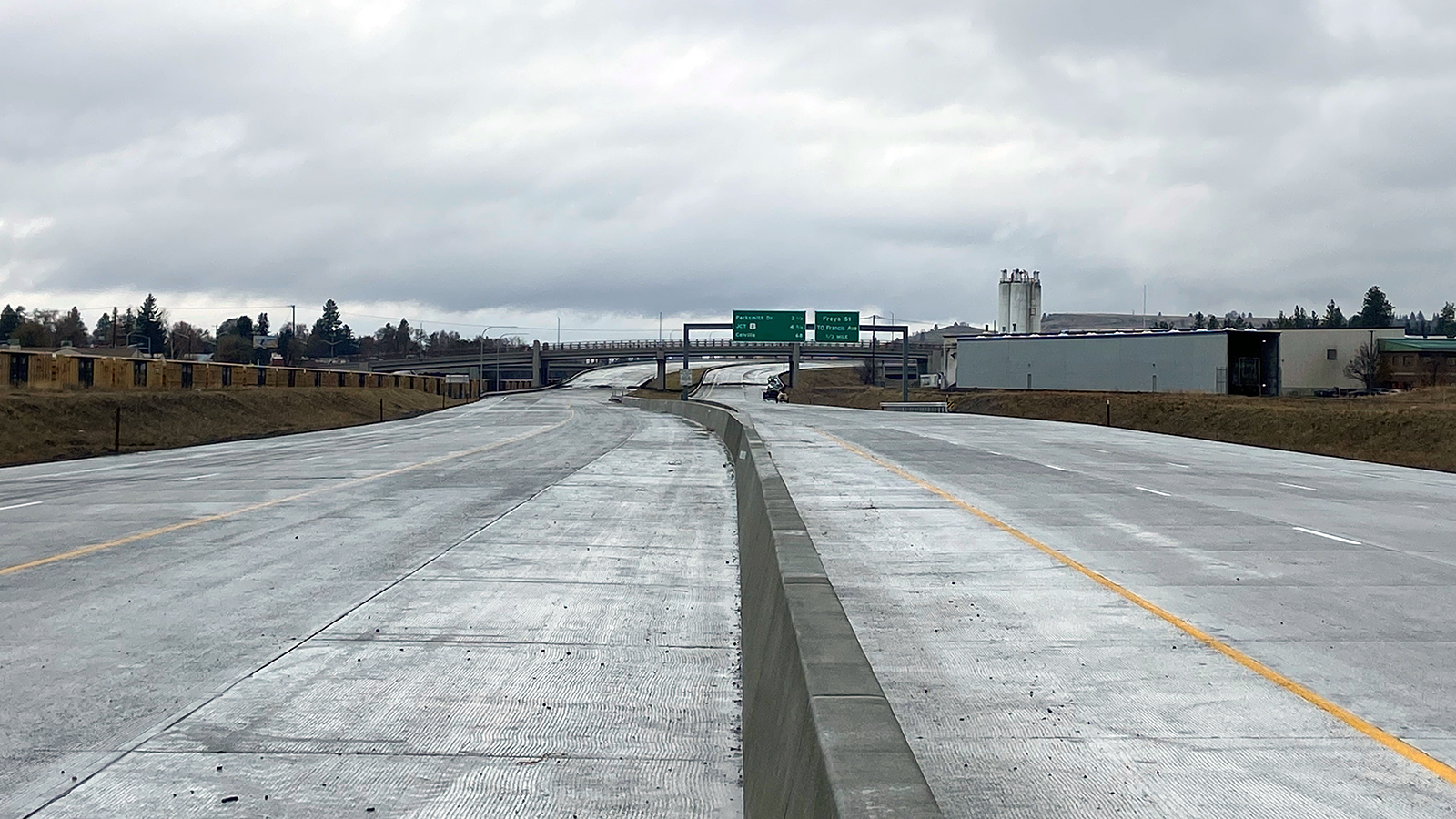 |
| The new link of the North Spokane Corridor opened on November 16 |
How we got here
The first plans for a north-south freeway in Spokane were adopted in 1958 with an estimated cost of $13 million. However, interstate freeways were prioritized over a north-south freeway and the project never gained traction.
In 1970, the Department of Highways (now WSDOT) released a “Corridor Study for North Spokane and North Suburban Area Freeway.” The recommended route was west of its current location, along Hamilton and Nevada streets.
An environmental statement was completed in 1972 but never approved and, in 1974, funding for a north-south freeway was cut from the state budget.
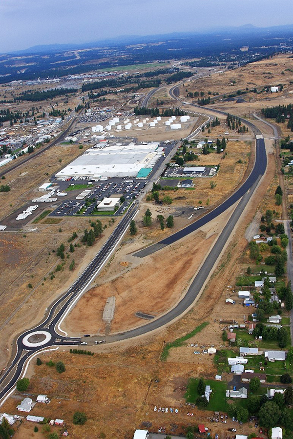
Between 1985 and 1988 the Spokane Regional Council identified a lack of regional facilities on the north side of Spokane as a major problem and requested a short and long-term “North Spokane Transportation Study.” Those studies were completed along with the recommendation to build a North Spokane Corridor along Market Street with an estimated cost of $400 million.
 |
| Three alternative North Spokane Corridor options based on traffic studies in 1985 |
In 1997, the Final Environmental Impact Statement was approved, and the Federal Highway Administration allowed the design and build of the NSC to begin.
In 2000, the Washington State Legislature approved a supplemental biennial budget which paved the road to begin construction of the project.
One year later, in 2001, the NSC broke ground for the first project: Hawthorne Road to Farwell Road.
 |
| The community celebrated the first ground breaking of the North Spokane Corridor program on Aug. 22, 2001. |
Work continued with the first 3.5-mile drivable link opening in 2009 between Francis Avenue and Farwell Road. Three years later, in 2012, the entire north half of the NSC fully opened to traffic, completing the first 5.5 miles of road while the adjacent Children of the Sun Trail opened from Freya Street to the Wandermere interchange.
 |
| Construction of the Wanderemere Bridge in 2010 (left) and the NSC between Francis Avenue and Farwell Road (right) |
Okay, take a breather. That’s a lot to consume, but it is worth pausing momentarily to mention that funding was available intermittently for the first decade-plus of the corridor’s construction; It was never fully funded, and a significant part of the corridor was constructed with a Federal TIGER Grant. However, that all changed in 2015 when state legislators passed the Connecting Washington package, which fully funded the NSC for the first time in project history. That funding spread out in each two-year transportation budget through 2030.
 |
| Construction of the Freya interchange and roundabout |
Let’s continue.
Work progressed south of Francis Avenue in 2018 with the construction of a new segment between Columbia and Freya Streets. The following year, we broke ground on a key project that realigned the BNSF railroad tracks to make way for the NSC to be built to the Spokane River.
 |
| Crews work through the winter to realign the BNSF railroad tracks in 2021 |
In 2020, construction continued south from Columbia Street to the Spokane River. The Wellesley interchange was included in this segment of the project, as was the extension of the Children of the Sun Trail. The first segment of the NSC south of the Spokane River near Spokane Community College got underway. The project known as the “Skyway” is also the first elevated section of the NSC to be constructed and was granted substantial completion as of November 1.
 |
| The Skyway project at SCC was completed on Nov. 1, 2023. |
Okay, the slingshot energy has reached max potential. There’s no going back now.
Where we are going
So, what’s next, and when will the NSC *deep breath in* finally be completed?
First, let’s talk about Thursday’s celebration of progress. The opening of the Wellesley interchange adds 1.5-miles of drivable pavement that connects to the Freya interchange to the north. Drivers can now get on and off the NSC at Wellesley Avenue (which also reopens after more than four years of construction), bringing the total section of drivable NSC to seven miles.
 |
| Celebrating the completion of the newest section of the NSC earlier this month |
Now turn your attention south of Wellesley. The remainder of Spokane River to Columbia project is nearly complete, but the section from Wellesley to the river won’t be drivable for some time because, well, there is currently nowhere to go when you reach the banks of the river.
Speaking of the Spokane River, the project to cross it is already underway. Once complete, it may very well provide the most picturesque section of the NSC with its architecturally appealing twin bridges.
 |
| A rendering of the NSC and Children of the Sun Trail crossing the Spokane River |
As mentioned, the portion just south of the river at SCC is complete.
In 2024, the next two phases of the project between Sprague Avenue and the Spokane River will break ground.
Drumroll please.
Then in 2025, we will begin work on the final project before completion of the NSC: The connection to Interstate 90. Yes, we are only two years away from starting the final leg of the project. Light is indeed at the end of the tunnel.
The connection to I-90 will take five years to complete. It will require patience from the traveling public while it creates detours and lane closures. Once complete, it will ease the burden of routes like Division Street by allowing freight to flow freely from US 395 to I-90. In addition, moving freight off surface streets will decrease emissions and fuel consumption through direct routing and the reduction of congestion.
Beyond the freeway, the Children of the Sun Trail will continue south by connecting into the Ben Burr Trail, Centennial Trail and others. This also gives opportunity for us, the City of Spokane and Spokane Transit Authority to reimagine Division Street to include Bus Rapid Transit, giving more opportunity for alternative modes of transportation. All of which will coincide with the completion of the NSC.
So, will the NSC be built in your lifetime? If you’ve read this far, you might be convinced. If you’re still not, the thing we like to encourage people to do is to go see it with your own eyes. Drive by the towering twin bridges at SCC. Note the painted concrete stamps on the structure that pay homage to Spokane’s rich history of the river, wildlife, and the Spokane Tribe of Indians. Continue north across the river to Market Street and pay attention to the completed section of the corridor on your right. Then, enter the NSC at Wellesley Ave. and drive seven miles until it connects to US 395 in Wandermere.
The NSC is no longer mythical. It’s here and will be finished!
11 comments:
So by opening the corridor all the way to I-90 you’re going to reduce the truck traffic on Divison which means congestion is reduced and local car traffic will be much better. But, it will then allow you to close it back down to allow for more busses which nobody rides.
Got it.
Once the NSC is complete to Trent Ave will those on/offramps be opened and will traffic be allowed to use that section of Freeway? Or will we be waiting for another 7 years for the next section to open to traffic?
Why no ramps at Euclid so traffic can use upriver dr.? Also, if this was any other city, this freeway would of been done in 2 or 3 years. The State of Washington has no care for the Spokane area. Even, the Tri-Cities has a better freeway system than Spokane.
Great work WSDOT! It's not easy. Our family appreciates everything you do.
The fact the WSDOT brags about this accomplishment is almost laughable. The work they accomplish in Western Washington is constant and without financial constraint. Poor Spokane has been needing this freeway for over 40 years and has always been denied until recently. It is sad how slow the WSDOT is on this project. Even the Snoqualmie Pass project, which receives much colder temperatures, much more traffic, and tons more snow is moving along quicker than the North/South Corridor in Spokane. Nothing to brag about WSDOT - when it comes to Spokane you move at a snail's pace.
Question: coming down from South Hill where will the the on ramp be to hookup with new 395 corridor?
Typical Washington state build. Notice how the freeway over SCC is only a 4 lane, when 6 is needed and it should be this close to the center of town, an 8 lane. If you travel to a real state and see highways in say Las Vegas. They build a head of population. In Las Vegas my son works 30 miles from home, takes me 22 minutes at the normal flow of traffic. Working in Spokane I put in a customers address, 9.1 miles and 47 minutes. The new freeway goes around the bulk of the city, there is no freeway through it still. What is the bulk area to have a freeway through? That is high drive to Carnahan, northwest boulevard to green street. 57th to Windermere. The center of which and being useful is Nevada. But there is already a bowl of ramps there now you say? Because that is where it belongs. It was abandoned for decades and they made into a Hamilton street exit in the late 80s-early 90s. So once completed you still need to drive through town on 30 MPH roads with millions of cars and hundreds of traffic lights to get anywhere. People in Deer Park will get great use of it though. At best because it bypasses most of town it'll save 10 minutes about 20% of the time.....
Andge2, yes, opening the corridor to I-90 will reduce truck traffic not only on Division, but Freya, Market, Argonne and Maple Street. Congestion will be reduced on local city streets which will allow for us and the city to reimagine Division Street. With reimagining Division Street, Spokane Transit is going to implement Bus Rapid Transit, similarly to the city line. If you'd like to learn more about the future bus rapid transit, we would encourage you to visit their website to learn more: https://www.spokanetransit.com/division-street-brt/
The Road Less Traveled, this is still in discussion. The Trent interchange doesn’t have capacity for all the traffic that would use it if it was the end of the NSC; it is designed to handle the capacity when the full NSC is open to I-90.
JBF138, there are ramps at Wellesley and Trent. The more ramps that are added to a freeway, the more traffic gets slowed down on the freeway due to people slowing down to enter and/or exit. Also, WSDOT’s design guidance is 1 mile minimum between ramps in an urban area and the distance between Euclid and Wellesley is less than 1 mile.
Dennis Stewart, the on-ramp to the North Spokane Corridor from I-90 will be between Altamont and Freya Streets. So, if coming down the west end of the South Hill, you will want to get on EB I-90 at Walnut, then access the NSC just east of Altamont. If coming down the east side of the South Hill, you’ll want to use Altamont or Freya to access the on-ramp to the NSC.
WSDOT comment policy
Post a Comment